John B. Holmes (surveyor)
Map of the Common Lands from 26th Street to 43rd Street Showing the Old Streets and Plots as Surveyed and Mapped in 1796
New York: July 1872
Lithograph
33.25 x 24.75 inches, overall
Sold, please inquire as to the availability of similar items.

Large Map of Midtown Manhattan
John B. Holmes, New York: 1872
John B. Holmes, New York: 1872
This item is sold. It has been placed here in our online archives as a service for researchers and collectors.
- Please inquire as to the availability of similar items currently in stock, or use the navigation bar above to browse our site for currently available items.
- Find guidelines for the use of images from georgeglazer.com.
- To see more archived items, view our directory.
- Find information about selling your art and antiques.


 |
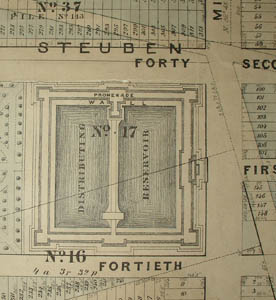 |
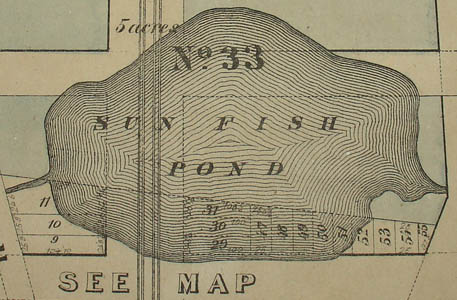
Map of a portion of Midtown Manhattan, from Broadway and Bloomingdale Road in the west to the Eastern Post Road and Lexington Avenue in the east, and from Madison Square and 26th Street in the south to the south side of 43rd Street in the north. During the colonial period, most of this area had been part of the Common Lands, mostly uninhabited rocky terrain in the center of the island that was owned by the city, which had been surveyed and mapped in 1796 by Casimir Goerck. In addition to the Eastern Post Road, the map includes many streets that no longer exist or have different names. Bloomingdale Road was the name by which the northern section of Broadway was known, until it was renamed Broadway in 1899. Other such streets include a major north-south artery called Middle Road, and an east-west street labeled "Cross Road or Lowes Lane." 42nd Street is also labeled Steuben Street, and Sixth Avenue is also labeled "Albany Ave. or West Road." Other interesting features include the New Fish Pond between 31st and 32nd Streets, and the Distributing Reservoir and neighboring park bounded by 40th and 42nd Streets and Fifth and Sixth Avenue. East of Lexington Avenue is labeled Kips Bay Farm. Landowners of large parcels are named. Below the cartouche is a detailed listing of the parcels that were numbered and sold, according to a map dated March 1, 1796, "purporting to have been made by Casimir T.H. Goerck, City Surveyor, and which he divided into parcels, numbered and sold by the Corporation." There is a compass rose in the upper right corner. Areas of the map are colored in shades of blue and brown. A note on the map explains, "The uncolored parts were not a portion of the Common Lands."
A Holmes map of Beekman Hill, owned by the George Glazer Gallery, was included in The Greatest Grid, an exhibition at the Museum of the City of New York (December 2011 through July 15, 2012) of maps documenting the development of the grid system of mapping Manhattan. It was also illustrated and described in the book accompanying the exhibition, as is a 19th century reproduction of Goerck's 1796 Map of the Common Lands.
Read more about The Greatest Grid exhibition and book, or order the book here.This map was part of series drawn by John Bute Holmes, Esq., the City Surveyor, which he began some time before 1870, comparing the large estates then making up most of the city with surveys made in the late 18th century. Holmes's maps enabled a comparison between present-day lot divisions, roads and estate boundaries and earlier ones, as a resource for lawyers, landowners and historians. Fifteen of Holmes’ published maps were listed in an article in The Historical Magazine in 1873, which noted then that Holmes was still at work on the series. This map is not included in that article, perhaps because the map was published only shortly before the article appeared.
Full title and publication information: Map of the Common Lands from 26th Street to 43rd Street Showing the Old Streets and Plots as Surveyed and Mapped in 1796, by Cassimer T.H Goerck, City Surveyor, And the Distance between those old Streets and our Present Streets by J.B. Holmes, C.E. City Surveyor, 39 Nassau Street, July 1872.
References:
Ballon, Hilary, ed. The Greatest Grid: The Master Plan of Manhattan 1811-2011. New York: Museum of the City of New York and Columbia University Press, 2012. Item 5. pp. 22-23.
The Historical Magazine, and Notes and Queries, Concerning the Antiquities, History and Biography of America. Vol. 2, No. 4, Third Series. Morrisania, NY: Henry B. Dawson, October 1873. pp. 260, 262. Online at Google Books: http://books.google.com/books?id=hdoOAAAAYAAJ (18 November 2011).
Peters, Harry T. America on Stone. U.S.: Doubleday, Doran, 1931. pp. 285-286.