W. Earle Andrews (engineer)
Air Map/ Fire Island Restoration/ Ocean Parkway and Boat Channel/ Suffolk County New York
New York: c. 1938-39
Black and white photographic print
11 inches x 134 inches (11 feet 2 inches), overall
Sold, please inquire as to the availability of similar items.

Fire Island Aerial Map
Photographic Restoration Map, c. 1938-39
Photographic Restoration Map, c. 1938-39
This item is sold. It has been placed here in our online archives as a service for researchers and collectors.
- Please inquire as to the availability of similar items currently in stock, or use the navigation bar above to browse our site for currently available items.
- Find guidelines for the use of images from georgeglazer.com.
- To see more archived items, view our directory.
- Find information about selling your art and antiques.

Full map (above) with details (below).
 |
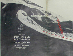 |
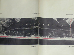
Long photographic map showing aerial view of a 42.7 mile stretch of Fire Island from Fire Island State Park to Hampton Beach. According to family history, this map was published shortly after the Great Hurricane of 1938 to illustrate proposed restoration to Ocean Parkway and the boat channel for damage caused by the hurricane.
"Proposed Protective Fill & Ocean Parkway" and a planned bridge at Smith Point are indicated with red outlines. "Boat Channel" between Fire Island and Long Island is indicated by white dotted lines. Sections identified in the top margin are: Fire Island State Park, Saltaire, Fair Harbor, Ocean Beach, Point O' Woods, Cherry Grove, Water Island, Long Cove, Smith Point & Smith's Point Bridge, Moriches Inlet, Westhampton Beach, Quogue, Tiana Beach, Ponoquogue and Hampton Beach.