Edmund Blunt (1799-1866) (surveyor)
W. Hecker (cartographer)
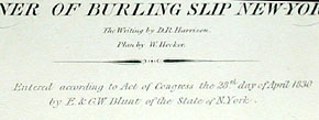
D.R. Harrison (lettering)
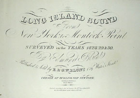
Long Island Sound From New York to Montock Point
Surveyed in the Years 1828, 29, & 30
E. & G.W. Blunt, 179 Water Street, Corner of Burling Slip, New York: April 28, 1830
Black and white engraving, mounted on blue back as issued
80 x 22 inches
Sold, please inquire as to the availability of similar items.

Long Island Sea Chart
Long Island Sound from New York to Montauk
Long Island Sound from New York to Montauk
This item is sold. It has been placed here in our online archives as a service for researchers and collectors.
- Please inquire as to the availability of similar items currently in stock, or use the navigation bar above to browse our site for currently available items.
- Find guidelines for the use of images from georgeglazer.com.
- To see more archived items, view our directory.
- Find information about selling your art and antiques.
 |
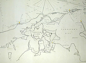 |
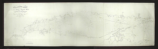
Fine and rare sea chart of Long Island Sound, showing the waters comprising the Sound in the center, surrounded by the south coast of Connecticut and the north shore of Long Island to the tip of Montauk.
Light houses indicated with red dots and yellow accents. Some of the locations noted are: New Rochelle, Saw Pitts Landing, Lloyds Neck, Eatons Neck, Smith Town Bay, New Haven, Shelter Island, New London, Gardiner's Bay, Plumb Island, Fishers Island Sound, Montauk, and Sag Harbor.
Edmund Blunt (1799-1866) was the son of Edmund March Blunt, a New York map and book publisher. The Blunt publishing firm was most famous for various editions of The American Coast Pilot, published in New York starting in the early 19th Century. Edmund became an assistant to Ferdinand Rudolph Hassler, conducting map surveys for the U.S. Coast Survey, and contributed surveys to his father's publishing firm.
The Blunt firm originally published a chart of Long Island sound, from 1805 to 1827, based on surveys by Cahoone & Fosdick. This revised edition extended to a larger area, with updated and more detailed survey information. It was published in 1830 by the firm, then known as E. & G.W. Blunt. Incidentally, in 1852 the Blunt firm published 16-inch terrestrial and celestial globes copyrighted 1852 by Charles Copley.
This chart was part of collection of charts and nautical items that descended in the family of Capt. Allen Lavender and his son Capt. Albert W. Lavender. They were a sea family from Nova Scotia and the Provincetown, Cape Cod area. Their charts were preserved in a large "Chart Chest."
Reference:
Guthorn. United States Coastal Charts. p. 65.