Frederick W. Beers (1839-1933) (editor/cartographer)
Charles Hart (printer)
L.E. Neuman (engraver)
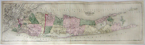
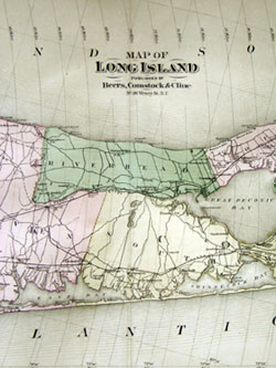
Map of Long Island
from Atlas of Long Island, New York
Beers, Comstock & Cline, 36 Vesey St. N. Y.: 1873
Hand colored engraving
13.5 x 52 inches, printed borders
15.5 x 53 inches, overall
Sold, please inquire as to the availability of similar items.

Frederick Beers Map of Long Island
from Atlas of Long Island, New York, 1873
from Atlas of Long Island, New York, 1873
This item is sold. It has been placed here in our online archives as a service for researchers and collectors.
- Please inquire as to the availability of similar items currently in stock, or use the navigation bar above to browse our site for currently available items.
- Find guidelines for the use of images from georgeglazer.com.
- To see more archived items, view our directory.
- Find information about selling your art and antiques.
 |
 |
 |
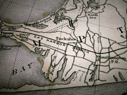 |
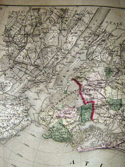
Large scale map of Long Island also showing Manhattan, Staten Island, and Hudson County in New Jersey. The longitude west of the Greenwich meridian, as well as the longitude east of Washington D.C. are both given, as well as lines of latitude and radial distances from City Hall in Manhattan at intervals of two miles. The various counties of Long Island are colored in shades of pink, yellow, and green. Highways, railroads, and important roadways are depicted throughout, with greater detail delineating individual streets in the New York City Area. The map is from the first atlas produced of Long Island. Atlas of Long Island, New York contained mainly property maps, and with its attractive and colorful plates was evidently a financial success. Its maps have been frequently reprinted in facsimile editions throughout the 20th century.
Frederick W. Beers was a prominent atlas and map publisher from the Beers family of cartographers. In 1867, then located at 95 Maiden Lane in Manhattan, Beers published his Atlas of New York and Vicinity, collaborating with A.D. Ellis and G.G. Soule. In 1870, Frederick joined his cousin, James Botsford Beers (b. 1811), in founding J.B. Beers & Company, in New York. As this suggests, the Beers family members sometimes worked individually, and other times in collaboration with each other and/or with other surveyors and publishers. Between 1865 and 1900, the Beers family and collaborators produced atlases of more than 80 counties in 10 states, including Vermont, Maine, Massachusetts, Pennsylvania, Ohio, New York and Michigan, as well as city atlases, separately issued maps, and county histories. F.W. Beers lived in Brooklyn, where he was also employed as head of the map division in the Brooklyn Office of Public Records for 35 years. His long career continued until his retirement at the age of 90.
References:
Allen, David Yehling. Long Island Maps and Their Makers. Mattituck, NY: Amereon House, 1997. pp. 94-97.
Ristow, Walter W. American Maps and Mapmakers: Commercial Cartography in the Nineteenth Century. Detroit: Wayne State University Press, 1985. pp. 406-409.