James Lyne and William Bradford (after)
Plan of the City of New York from an actual survey - 1735
John Stanford (artist), New York: 1828
Pen and ink on paper
22.5 x 23 inches, overall
21.25 x 21.5 inches, image
Sold, please inquire as to the availability of similar items.

Lyne-Bradford Plan of New York from 1735
Rendered by John Stanford: 1828
Rendered by John Stanford: 1828
This item is sold. It has been placed here in our online archives as a service for researchers and collectors.
- Please inquire as to the availability of similar items currently in stock, or use the navigation bar above to browse our site for currently available items.
- Find guidelines for the use of images from georgeglazer.com.
- To see more archived items, view our directory.
- Find information about selling your art and antiques.
   |
 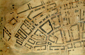 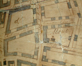 |
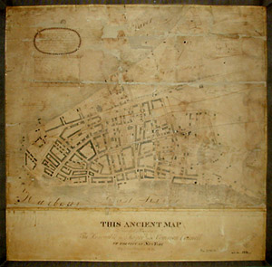
An American early 19th Century federal period unique hand-drawn pen and ink facsimile of the highly important seminal 18th Century British Bradford Map or Lyne Survey of New York City. James Lyne was the cartographer and William Bradford the printer of the original engraved map, issued in New York in 1731. Bradford dedicated the map to British Royal Governor John Montgomerie, who granted the Montgomerie Charter that year, establishing New York City as a municipality and reorganizing it into seven wards. The map shows the area of what is now downtown Manhattan. Street layout is shown and is accompanied by a key assigning letters and numbers to important buildings and churches appearing in the map.
According to the dedication, this example of the "ancient" map was executed in 1828 by John Stanford for the "Mayor and Common Council" of New York City. It is very similar to the Lyne Bradford map, though not identical, the variations apparently mostly in design elements. Research has not yet revealed anything about John Stanford. However, the late 1820s were a time of rapid expansion for New York City, with "new streets being built and some three thousand buildings...under construction," and the absorption of once separate communities to the north, such as the village of Greenwich. (Cohen and Augustyn, 114)
There are only three known copies of the original 1731 map, one of which is in the Phelps Stokes Collection of the New York Public Library. According to the NYPL website, "Of the plans in the Phelps Stokes collection, the most important are the first and fourth issues of the Bonner maps of Boston issued in 1722 and 1743, and the best of three known impressions of the Bradford map or Lyne Survey of New York, depicting the city in 1730." (emphasis added)
This map would be an important cornerstone to any collection of New York City or American maps. It affords the collector an opportunity to own an example of the first printed plan of the city to have been published anywhere (Cohen and Augustyn, 54). 18th Century examples of the printed map or exceedingly rare. Moreoever, this map is a unique manuscript, and particularly interesting as an American example of the British map, created for the mayor of New York in 1828, in the early planning stages of the expansion of the City.
William Bradford (1663-1752) was the printer of the original map. Born in Britain, he emigrated first to Philadelphia, where he set up the first press there and the first paper mill in the colonies. In 1690, he was put on trial for criticizing the Quaker government; no verdict was reached. He moved to New York City and set up its first press in 1693 and became royal printer, issuing some 400 items in the next 50 years, including the first American Book of Common Prayer, almanacs, pamphlets and the city's earliest newspaper, the New York Gazette. Little is known about the surveyor James Lyne, on whose work the plan is based; he held some minor posts and advertised his services as a tutor. The circumstances of the publication of the map are not known and it does not seem to have been promoted as a commercial venture, having been advertised just once in the Gazette in the issue of August 30 to September 6, 1731. "With the seal of the city and arms of the Crown decorating the map, along with its dedication to the governor, the plan has the look of an official document, which it very well could have been," (Cohen and Augustyn) since it shows the city divided into the seven wards that had been created by the Montgomerie Charter.
Cartouche upper right: Plan/ of the City of/ New York/ from an actual survey/ - 1735.
Dedication lower margin: THIS ANCIENT MAP/ Is respectfully Presented to/ The Honorable the Mayor and Common Council/ Of the City of New York/ By John Stanford/ 1828.
Facsimile cartouche upper left: To His Excellency/ John Montgomerie Esq./ [illegible] Gen'l and Gov in Chief/ His Majesty Provinces of/ New York, New Jersey &c./ this plan of the City of New/ York is humbly Dedicated by your/ Excellency's obed't & most humble/ Serv't Wm. Bradford.
References:
Cohen, Paul E. and Augustyn, Robert T. Manhattan In Maps 1527-1995. New York: Rizzoli, 1997. pp. 54-56.
"Lyne Plan 1728." http://freepages.genealogy.rootsweb.com/~blkyn/Map/Lyne.Plan.1728.html (showing original Lyne Bradford map, although dated incorrectly) (31 March 2003).
"Guide to the Research Collections." New York Public Library. http://digilib.nypl.org/dynaweb/williams/williams/@Generic__BookTextView/23934 (31 March 2003).
"William Bradford." The Columbia Electronic Encyclopedia. 1994, 2000. http://www.infoplease.com/ce6/people/A0808665.html (31 March 2003).