Henry Francis Walling (1825-1889) (surveyor)
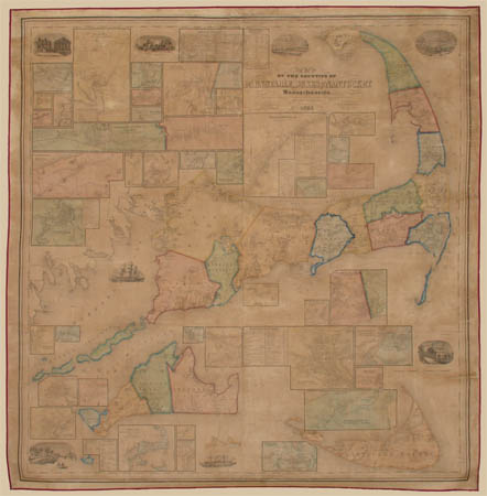
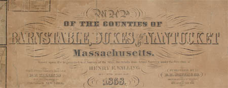
Map of the Counties of Barnstable, Dukes and Nantucket, Massachusetts, Based upon the Trigonometrical Survey of the State
H.F. Wallings Map Establishment (engraver, printer, colorist, mounter)
D.R. Smith & Co., Boston & New York: 1858 (publisher)
Hand-colored engraving, formerly varnished, linen backed
62 x 59 inches
Sold, please inquire as to the availability of similar items.

Large Wall Map of Cape Cod
Including Martha's Vineyard and Nantucket, H.F. Walling: 1858
Including Martha's Vineyard and Nantucket, H.F. Walling: 1858
This item is sold. It has been placed here in our online archives as a service for researchers and collectors.
- Please inquire as to the availability of similar items currently in stock, or use the navigation bar above to browse our site for currently available items.
- Find guidelines for the use of images from georgeglazer.com.
- To see more archived items, view our directory.
- Find information about selling your art and antiques.

 |
 |
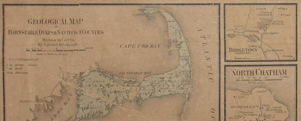
Large, impressive mid 19th century wall map of Cape Cod, also including Martha’s Vineyard and Nantucket. Subdivisions are hand-colored. The map encompasses Barnstable County, Dukes County, Nantucket County, Bourne, Sandwich, Falmouth, Mashpee, Barnstable, Yarmouth, Dennis, Brewster, Harwich, Chatham, Orleans, Eastham, Wellfleet, Truro, Provincetown, Gosnold, Gay Head, Chilmark, West Tisbury, Tisbury, Oak Bluffs, Edgartown, Nantucket, Chilmark, and Aquinnah. It shows features such as roads, railroads, drainage, public buildings, schools, churches, cemeteries, industry locations (e.g. mills, factories, mines, etc.), private buildings with names of property owners, town and county boundaries, etc. Physical relief is shown by hachures. Also includes numerous insets such as cadastral maps of individual county towns and villages, a geological map of county, as well as business directories, and tables of statistics and distances. Another example of this map is in the Harvard University Map Collection (see References below).
Henry Francis Walling was a surveyor and map publisher based in New York City. He was born and educated as a surveyor in Rhode Island. The first town maps based on his surveys, published in 1848 and 1849, convinced him there was a market for town plans commissioned by local officials. He opened his own business and by 1852 was able to expand it and move it to Boston (in later years he also operated the business in New York City and Cambridge, Massachusetts). According to scholar Walter Ristow, Walling, along with Robert Pearsall Smith, “unquestionably made the greatest contributions to town and county mapping” during the period between 1850 and 1880, and that many other successful mapmakers of the era owed their success to him. During his 40-year career, he had a hand in the publication of some 20 state and province maps, 280 county maps and over 100 of cities and towns. In 1855, Walling was appointed Superintendent of the State Map by the Massachusetts legislature and charged with updating and correcting the official state map. Between 1868 and 1885 Walling was the most active publisher of state atlases. These were generally collaborative ventures with other publishers, such as Ormando W. Gray, Robert Allen Campbell and Simon J. Martenet. In 1880, Walling began a period of government employment as a geographer, working for the U.S. Geological Survey from 1883 until his death in 1889. There he successfully advocated for federal-state cooperation in surveying and mapping, making a lasting contribution to American topographical mapping.
References:
“Barnstable, Dukes, and Nantucket counties, Massachusetts, 1858.” Harvard Map Collection Digital Maps. 2008. http://vc.lib.harvard.edu/vc/deliver/~maps/MAPRT_3763_B3_1858_W3 (22 June 2009).
Ristow, Walter W. American Maps and Mapmakers: Commercial Cartography in the Nineteenth Century. Detroit: Wayne State University Press, 1985. pp. 257, 327-338, 387, 427-431.