Frederick W. Beers (1839-1933) (after)
Shelburne
New York: c. 1869
Pen and ink, watercolor wash on paper
Divided in four sections, mounted on linen
29.5 x 22.5 inches, overall
28.25 x 21.75 inches, border
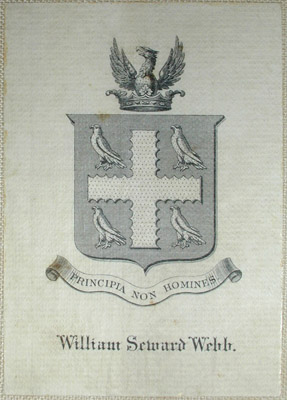
Provenance: William Seward Webb (with his bookplate verso)
Sold, please inquire as to the availability of similar items.

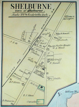
Shelburne, Vermont, Manuscript Map
F.W. Beers: 1869
F.W. Beers: 1869
This item is sold. It has been placed here in our online archives as a service for researchers and collectors.
- Please inquire as to the availability of similar items currently in stock, or use the navigation bar above to browse our site for currently available items.
- Find guidelines for the use of images from georgeglazer.com.
- To see more archived items, view our directory.
- Find information about selling your art and antiques.

 |
 |
 |
 |
 |
 |
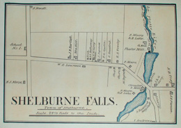
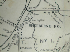
An important original manuscript map of Shelburne, Vermont, and Shelburne Bay on Lake Champlain , at a scale of 3 inches to the mile. The map includes two insets maps: Shelburne Falls Village, and Shelburne Village, both shown at 22.5 rods to the inch. Roads, railroads, rivers, and the districts of Shelburne are indicated, as well as homes labeled with the owners' names. It is executed in pen and ink, with color washes indicating the different districts in pink, green, faded orange, and yellow, with waters colored blue.
This map is very similar to the lithographed map of Shelburne in the F.W. Beers Atlas of Chittenden County, Vermont , published in New York in 1869. The example in the Beer's atlas includes a printed business directory incorporated not present in this manuscript. The manuscript map may have been either an original for the F. W. Beers atlas (upon which the small map in the atlas was based) or a custom design made by the Beers firm.
This map was formerly in the library of Dr. William Seward Webb, one of the most prominent Vermonters of the 19th century, closely associated with the development of Shelburne, a town south of Burlington, Vermont. With his wife Lila Vanderbilt (of the wealthy Vanderbilt family) he purchased land for a summer home there in 1881. Webb envisioned Shelburne Farms as a model for modern agriculture and hired the famous landscape designer Frederick Law Olmsted and forester Gifford Pinchot to design the grounds. The property featured the largest barn in America, a five-story structure built by Olmsted, large enough for 300 horses, a coach barn and a grand 100-room mansion, constructed in 1899. Today, Webb's legacy lives on as the Shelburne Museum, founded in 1947 as a living history museum, and Shelburne Farms, a non-profit foundation founded by Webb's descendants in 1972, to preserve the 1,400-acre working farm and promote land stewardship and agriculture.
Webb's bookplate is affixed on verso and features his family coat of arms -- a Greek cross separating four birds into corners, capped by a crown and eagle. The motto reads "Principia Non Homines." Additionally, a section of the original covers of the map (when it was in folding form) "Shelburne Chittenden Co. Vermont." is affixed verso.
Frederick W. Beers was a prominent atlas and map publisher from the Beers family of cartographers. In 1867, then located at 95 Maiden Lane in Manhattan, Beers published his Atlas of New York and Vicinity, collaborating with A.D. Ellis and G.G. Soule. In 1870, Frederick joined his father, James Botsford Beers (b. 1811), in founding J.B. Beers & Company, in New York.Frederick's brother, John Clark Beers, and John's son James Lemuel Beers, also joined in the business. As this suggests, the Beers family members sometimes worked individually, and other times in collaboration with each other and/or with other surveyors and publishers. Between 1864 and 1885, the Beers family and collaborators produced more than 125 atlases, mostly of counties, in 10 states, including Vermont, Maine, Massachusetts, Pennsylvania, Ohio, New York and Michigan, as well as city atlases, separately issued maps, and county histories. F.W. Beers lived in Brooklyn, where he was also employed as head of the map division in the Brooklyn Office of Public Records for 35 years. His long career continued until his retirement at the age of 90.References:
Nemethy, Andrew. " Shelburne, Vt.: A legacy of history, agriculture and art." American Profile. 7 April 2001. http://www.americanprofile.com/issues/20010401/20010401ne_687.asp (9 February 2004)
Allen, David Yehling. Long Island Maps and Their Makers. Mattituck, NY: Amereon House, 1997. pp. 94-97.
Ristow, Walter W. American Maps and Mapmakers: Commercial Cartography in the Nineteenth Century. Detroit: Wayne State University Press, 1985. pp. 406-409.