Giovanni Antonio Bartolomeo Rizzi Zannoni (1736-1814) (cartographer)
Carte Geo-Hydrographique du Golffe du Mexique et de ses Isles
[Geohydrographic Map of the Gulf of Mexico and Its Islands]
from Atlas Moderne ou Collection de Cartes sur Toutes les Parties du Globe Terrestre par Plusieurs Auteurs [Modern Atlas or Collection of Maps on All the Parts of the Terrestrial Globe by Several Authors]
Jean Lattré & J. Thomas, Lattré Graveur, Rue St. Jacques, Bordeaux: 1762
Hand-colored engraving
11.5 x 18 inches, plate mark
13.75 x 18.5 inches, overall
Sold, please inquire as to the availability of similar items.

Rizzi Zannoni - Caribbean Map - 18th Century
Geohydrographic Map of the Gulf of Mexico and its Islands
Geohydrographic Map of the Gulf of Mexico and its Islands
This item is sold. It has been placed here in our online archives as a service for researchers and collectors.
- Please inquire as to the availability of similar items currently in stock, or use the navigation bar above to browse our site for currently available items.
- Find guidelines for the use of images from georgeglazer.com.
- To see more archived items, view our directory.
- Find information about selling your art and antiques.
 |
 |
 |
 |
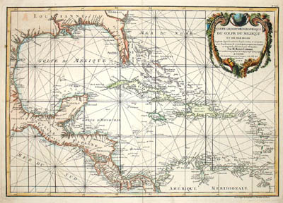
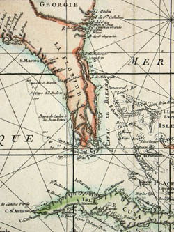
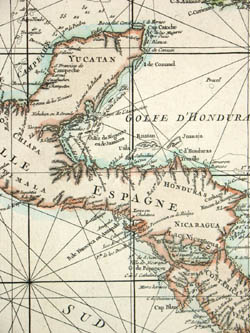
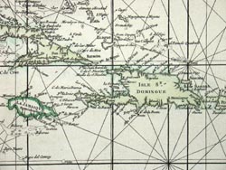
Map of the Caribbean and Gulf of Mexico showing the various islands and continental coastlines according to the 18th century Venetian cartography of Rizzi Zannoni. Illustrated with navigation rhumb lines in waters. Includes notations of the sea depths, such as off the coast of Florida and the Yucatan peninsula. The baroque cartouche in the upper right incorporates a cornucopia, symbolic of the abundant natural resources of the New World.
Giovanni Antonio Bartolomeo Rizzi Zannoni was one of the leading cartographers of the late 18th century, as well as being an astronomer, surveyor and mathematician. Born in Padua, he worked in Venice and was engaged by the governments of Austria and France to produce maps. Rizzi Zannoni was the first to execute the triangulation of Poland, assisting in the French and English border survey of American in 1757, and serving as the hydrographer of the Dépot de Marine. He was also a member of the Cosmographic Society of Göttingen, a town in Saxony, Germany, home to the University of Göttingen. Rizzi Zannoni is known for his world atlas, the French edition of which was published in 1762 as Atlas Moderne by Lattré in Bordeaux. In 1781, he was invited by the Bourbon rulers of the Kingdom of Naples to direct the Topographical Office, among the first governmental cartographic agencies in Europe. There he produced celebrated land and maritime atlases of the region, as well as many separately issued maps. His Atlante Marittimo delle due Sicile (1793) is cited by map historian R.V. Tooley as “remarkable for a marvelously minute attention to detail, and amply deserves the commendation passed upon it by Sir George Fordham” (Tooley, 21).
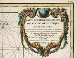
Full Cartouche: “Carte geo-hydrographique du Golfe du Mexique et de ses isles. Construit d'apres les memoires les plus recens, et assujeties, pour l'emplacement de ces principales positions aux latitudes et longitudes, determinées par observation. Par M. Rizzi Zannoni, de la Société Cosmographique de Gottingue, proff. de geograph. A Paris, Chez Lattré Graveur, rue St. Jacques, a la Ville de Bordeaux. A.P.D.R.” [Geohydrographic map of the Gulf of Mexico and its islands. Constructed after, and subject to, the most recent dissertations for the sites of these prinicipal positions of latitutdes and longitudes, determined by observation. By Mr. Rizzi Zannoni, of the Cosmographic Society of Göttingen, professor of geography. Published in Paris at Lattre Engraver, St. Jacques Street, in the city of Bordeaux.]
Reference:
“Cartografica Nautica: Italia, Il Regno di Napoli.” Sulla Cresta dell’Onda. http://www.sullacrestadellonda.it/cartografia/italia9.htm (3 October 2005).
Tooley, R.V. Maps and Map-Makers. 4th Ed. New York: Bonanza Books, 1970. p. 21.