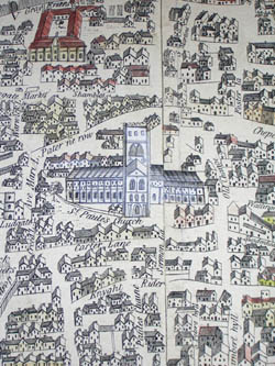
London and Westminster in the Reign of Queen Elizabeth Anno Dom. 1563
J. Wallis, 16 Ludgate Street, London: October 30, 1789
Hand-colored engraving, on linen and leather backing, as issued
15 x 40 inches, printed border
16.5 x 42 inches, overall
Sold, please inquire as to the availability of similar items.
To see other Wallis maps on our site, use our site search engine.
Large detailed panoramic pictorial map of London as it appeared during the reign of Queen Elizabeth I in 1563, engraved in 1789 to illustrate the growth of the city. Various important sites are featured in bird’s-eye view pictorial style, and identified with letters in two keys, including Covent Garden, Charing Crosse, the Tower of London, Shakespeare’s Playhouse, St. Paule’s Church [St. Paul’s], Nonsuch House, the London Bridge, and City Walls. Trees, gardens, parks, and rolling hills are also illustrated, as are boats in the Thames River.
The map bears an explanatory inset description:
LONDINUM ANTIQUA.
This PLAN shews the ancient extent of the famous Cities of LONDON and WESTMINSTER as it was near the beginning of the Reign of Queen Elizabeth these Plates for their great scarcity are re engraved to oblige the Curious and to hand to Posterity this Old Prospect whereby at one view may be seen how much was built of this populous CITY and parts adjacent at that time.
Radulphus Aggus in his Oxoniæ Antiqua published A. D. 1578, says, ‘Near ten years past the Author made a doubt whether to print or lay this work aside Until he first had LONDON platted out.’
The following Buildings were not erected when this Plan was taken
The Whitehall Banquetting House the 1st Building was of Timber.
The Royal Exchange (not built) before 1570.
Moor Fields not divided nor planted.
Lambs Conduit on Snow hill about 1580.
Paget Place called so till the death of Lord Paget Anno. 1563.
John Wallis (d. 1818) was a London game, book, map and print maker and seller, operating from 1775, when his business was called the Map Warehouse. In 1805, he opened the Instructive Toy Warehouse. He published music imprints, maps by John Cary, and children’s material, co-operating with the Newberys and various provincial retailers. With his son Edward, who joined the business in 1813, he also operated Wallis’s, a circulating library and reading room. Together they published under the imprint Wallis and Son or John & Edward Wallis. Edward succeeded his father and published under his own name until about 1847, at which time the Wallis stock was taken over by J. Passmore. John Wallis’ son, John Jr. (b. 1780) was also involved in publishing. After an apprenticeship to his father, he worked for the London Stationers’ Company and briefly operated his own London firm. He then relocated to the coastal resort of Sidmouth, where he established his own circulating library and reading room, the Marine Library, and published aquatints, lithographs and illustrated books, many focusing on the Devon region.
The Wallis family (John Sr. and Edward) produced pictorial maps as well as cartographic and historical jigsaw puzzles and folding board games. John Wallis Sr. published London and Westminster in the Reign of Queen Elizabeth Anno Dom. 1563 (1789) a pictorial map of London from a historical perspective and Wallis's Complete Voyage Round the World: A New Geographical Pastime (1796). Edward Wallis published a Picturesque Round Game of the Produce & Manufactures, of the Counties of England & Wales (c. 1826-1837) and a similar game map of the Eastern United States, Game Of The Star-Spangled Banner or Emigrants to the United States. Other Wallis family publications include A Tour through England, A Tour through Europe, A Tour Through Scotland and The Genealogy of the Kings of England; from Egbert 1st King to the Present Time.
References:
“John Wallis (publisher).” Wikipedia. 24 January 2005. http://en.wikipedia.org/wiki/John_Wallis_(publisher) (28 April 2005).
Maxted, Ian. “Etched on Devon’s Memory. Publishers and engravers: the production of Devon topographical prints.” Devon Library and Information Services. 1 July 2004. http://www.devon.gov.uk/library/locstudy/etchpubl.html (28 April 2005).
Maxted, Ian. "The London book trades 1775-1800: a preliminary checklist of members." Exeter Working Papers in British Book Trade History. U.K.: Devon Library and Information Services. 20 June 2001. http://www.devon.gov.uk/library/locstudy/bookhist/lonw.html (25 March 2003).