Wallis’s Picturesque Round Game of the Produce & Manufactures, of the Counties of England & Wales
Edward Wallis, 42 Skinner Street,
London (original publisher)
J. Passmore, 18 Fleet Lane, Farringdon Street,
London: c. 1847-1850s (issued by)
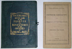
Hand-colored aquatint dissected and folding, as issued
26.25 x 20 inches, overall
7 x 5.5 inch embossed green covers
Sold, please inquire as to the availability of similar items.
Search for other Wallis maps on our site
with our search engine.
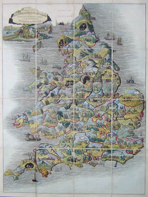
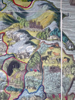
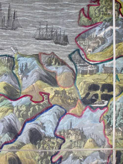
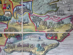
Educational map game of England and Wales, designed to teach notable aspects of each county. Produce and manufacturers are illustrated in pictorial style and numbered on variously colored counties, together with famous sites and popular pastimes. The map also includes topographical features such as mountains, bodies of water and forests. Ships dot the seas. The cartouche, in the form of a castle wall in ruins, is surrounded by scenes of a farmer and wife, railroad, ships, etc. The game takes the form of a “dissected” (sectioned folding) map, that opens into a race game that starts at the mouth of the Thames and travels along 151 stops to the destination of London. For example number 10, Ely, was known for eels and strawberries, and number 126, Dorchester, was known for butter and strong beer. Originally published by Edward Wallis between 1826 and 1837 (see Whitehouse), Wallis’s publication line appears on the map. The name of John Passmore, who took over Wallis’s stock in 1847, appears on the instruction booklet.
The Bodleian Library at Oxford University in England has both the Wallis and Passmore editions of this game in their collection, and both the British Library and the University of Wales have the 1844 edition. The game was innovative with respect to its cartographic style combining correct county boundaries and non-traditional pictorial design.
The map is dissected, backed on linen, and folds into cloth covers, as issued. A 12-page booklet published by Passmore includes rules, explanations, and data. Apparently the game was originally issued with a “Card” containing 9 letters, 9 numbers, 2 crosses and one blank, not present in this set. Players were to supply their own “counters” or “tetotums.” The original booklet suggests that the game be played for a prize such as “fruit, raisins, nuts, cakes, &c,” or if played for money, it was suggested that “the winners will have the privilege of contributing the money that have gained to any benevolent or charitable object which shall be recommended by the lady of the house.”
John Wallis (d. 1818) was a London game, book, map and print maker and seller, operating from 1775, when his business was called the Map Warehouse. In 1805, he opened the Instructive Toy Warehouse. He published music imprints, maps by John Cary, and children’s material, co-operating with the Newberys and various provincial retailers. With his son Edward, who joined the business in 1813, he also operated Wallis’s, a circulating library and reading room. Together they published under the imprint Wallis and Son or John & Edward Wallis. Edward succeeded his father and published under his own name until about 1847, at which time the Wallis stock was taken over by J. Passmore. John Wallis’ son, John Jr. (b. 1780) was also involved in publishing. After an apprenticeship to his father, he worked for the London Stationers’ Company and briefly operated his own London firm. He then relocated to the coastal resort of Sidmouth, where he established his own circulating library and reading room, the Marine Library, and published aquatints, lithographs and illustrated books, many focusing on the Devon region.
The Wallis family (John Sr. and Edward) produced pictorial maps as well as cartographic and historical jigsaw puzzles and folding board games. John Wallis Sr. published London and Westminster in the Reign of Queen Elizabeth Anno Dom. 1563 (1789) a pictorial map of London from a historical perspective and Wallis's Complete Voyage Round the World: A New Geographical Pastime (1796). Edward Wallis published a Picturesque Round Game of the Produce & Manufactures, of the Counties of England & Wales (c. 1826-1837) and a similar game map of the Eastern United States, Game Of The Star-Spangled Banner or Emigrants to the United States. Other Wallis family publications include A Tour through England, A Tour through Europe, A Tour Through Scotland and The Genealogy of the Kings of England; from Egbert 1st King to the Present Time.
References:
“John Johnson Collection Exhibition 2001: Juvenilia. Item 282.” Bodleian Library. 2001. http://www.bodley.ox.ac.uk/johnson/exhibition/282.htm (20 December 2004).
“John Wallis (publisher).” Wikipedia. 24 January 2005. http://en.wikipedia.org/wiki/John_Wallis_(publisher) (28 April 2005).
Maxted, Ian. “Etched on Devon’s Memory. Publishers and engravers: the production of Devon topographical prints.” Devon Library and Information Services. 1 July 2004. http://www.devon.gov.uk/library/locstudy/etchpubl.html (28 April 2005).
Maxted, Ian. "The London book trades 1775-1800: a preliminary checklist of members." Exeter Working Papers in British Book Trade History. U.K.: Devon Library and Information Services. 20 June 2001. http://www.devon.gov.uk/library/locstudy/bookhist/lonw.html (25 March 2003).
“More Gems from the Horton Collection of Children’s Material.” The University of Wales. 19 August 2004. http://www.inf.aber.ac.uk/academicliaison/horton/roundgame.asp (20 December 2004).
Whitehouse, F.R.B. Table Games of Georgian and Victorian Days. United Kingdom: Priory Press Ltd., 1971. p. 14.