Abraham Ortelius (1527-98)
Romani Imperri Imago
from Typus Orbis Terrarum
Amsterdam: c. 1600
Hand-colored engraving
17 x 22 inches
Sold, please inquire as to the availability of similar items.

Romani Imperri Imago
Abraham Ortelius, c. 1600
Abraham Ortelius, c. 1600
This item is sold. It has been placed here in our online archives as a service for researchers and collectors.
- Please inquire as to the availability of similar items currently in stock, or use the navigation bar above to browse our site for currently available items.
- Find guidelines for the use of images from georgeglazer.com.
- To see more archived items, view our directory.
- Find information about selling your art and antiques.
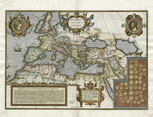
Historical map showing the extent of the ancient Roman Empire in Europe, North Africa, and the Middle East from Typus Orbis Terrarum, by Abraham Ortelius, an influential figure in the golden era of Dutch cartography and producer of the first modern atlas.
This map is richly decorated in the Mannerist style, with decorative cartouche, two portrait medallions of Romulus (the mythical founder of Rome) and a Roman soldier, as well as a genealogical tree of Roman emperors surmounted by a baby Romulus, his twin brother Remus and the she-wolf that, according to legend, cared for them as infants. A large sailing vessel decorates the Atlantic Ocean.
Based in Antwerp, Ortelius was a well-traveled and cultured man who ran a successful business as a print colorist and dealer in antiques, maps and books. He also built a large personal collection related to his interests in Classical history, including maps. Ortelius began to produce his own maps in about 1560, possibly as a result of his friendship with the great Dutch cartographer Gerard Mercator.
Shortly thereafter, Ortelius commenced his greatest project, the Theatrum Orbis Terrarum. As the greatest cartographic bibliographer of the period, Ortelius was able to prepare 53 map sheets based on the most up-to-date information. They were finely engraved by Frans Hogenberg with rich Mannerist details and strapwork cartouches. The atlas was first published in 1570 and was an immediate commercial success, being reprinted four times that year. In the next decades, Typus Orbis Terrarum was reprinted in a variety of languages, with many of the maps re-engraved and updated. Additional maps were added so that later editions contained up to 163 map sheets. The Ortelius atlas achieved instant fame as "the world's first regularly produced atlas," being the first atlas with maps prepared to a uniform format.
References:
Van den Broecke ORT-188.