Johann Baptist Homann (1664-1724) (editor)
Magna Britannia complectens Angliæ, Scotiæ et Hiberniæ Regna in suas Provincias et Comitanis divisa repræsentante
[Great Britain encompassing England, Scotland and Ireland...]
J.B. Homann and Homann Heirs, Nuremberg and Amsterdam: 18th Century
20.5 x 23.75 inches, overall
18.75 x 22.5 inches, printed border
Sold, please inquire as to availability of other Homann maps.

Map of Great Britain
Johann Baptist Homann: 18th Century
Johann Baptist Homann: 18th Century
This item is sold. It has been placed here in our online archives as a service for researchers and collectors.
- Please inquire as to the availability of similar items currently in stock, or use the navigation bar above to browse our site for currently available items.
- Find guidelines for the use of images from georgeglazer.com.
- To see more archived items, view our directory.
- Find information about selling your art and antiques.

 |
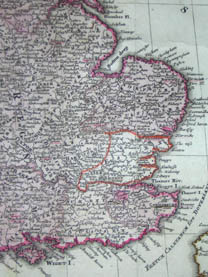 |
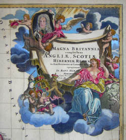
Map of the British Isles also showing the coast of France. Counties, cities, towns, rivers, and castles are well marked. A distance scale appears in the lower left corner with five different systems of measurement. A large allegorical decorative cartouche inscribes the title on a gold-fringed banner borne aloft by putti. A draped figure of Brittania seated before it gestures toward a lion and a unicorn holding up the coat of arms, resting her elbow on a large globe. In the upper left corner of the cartouche is an oval portrait of a bewigged man, probably the king.
Johann Baptist Homann, a former Dominican monk, became a celebrated cartographer of 18th century Nuremburg, Germany, producing maps and celestial charts (generally in atlases), and globes of high quality both in their geographic accuracy and aesthetic appeal. According to map expert R.V. Tooley: "The most important and prolific map-makers in Germany in the 18th century were the Homann family (1702-1813). The founder and principal member was Johann Baptist Homann. He set up his headquarters in Nuremberg and quickly dominated the German market. Nor did he confine his efforts to his homeland, but produced general atlases covering the whole world."
After settling in Nuremburg in 1688, Johann Baptist Homann was employed as a map engraver before founding his own firm in 1702. Homann’s geographical, celestial, and astronomical maps were published in a variety of states throughout the 18th century, which are generally difficult to distinguish from one another. Most of his geographical maps first appeared in Atlas Novus [New Atlas] (1714) and his celestial maps, produced in collaboration with Johann Gabriel Doppelmayr, were issued as part of various publications before being published as a collection posthumously by his heirs, most notably as Atlas Coelestis in quo Mundus Spectabilis et in Eodem Stellarum Omnium Phoenomena Notabilia, issued as 30 plates in 1742.
Homann’s geographical maps were frequently republished by the Homann heirs throughout the 18th century, most notably in Atlas Geographicus Maior (c. 1780) and Atlas Homannianus, (Amsterdam, 1731-1796). Homann was initially succeeded by his son, Johann Christoph Homann (1703-1730), then by his friend Johann Michael Franz (1700-1761) and stepsister’s husband Johann Georg Ebersberger (1695-1760). The company continued operations under different names until 1848.
References:
Dekker, Elly, et al. Globes at Greenwich: A Catalogue of the Globes and Armillary Spheres in the National Maritime Museum, Greenwich. London: Oxford University Press and the National Maritime Museum, 1999. p. 327.
Tooley, R.V., Maps and Map-Makers. New York: Bonanza Books, 1949. p. 27.
van Gent, Robert Harry. “The Atlas Coelestis (1742) of Johann Gabriel Doppelmayr.” 23 April 2003. http://www.phys.uu.nl/~vgent/doppelmayr/doppelmayr.htm (15 September 2004).