Guillaume de L'Isle (1675-1724) (after)
Charles Amadeus Berey (engraver)
Charles Simonneau (cartouche designer and engraver)
L’Italie [Italy]
Guillaume de l'Isle, Quai de l’Horloge, Paris: 1700
Hand-colored engraving
20 x 26.5 inches, overall
19.25 x 24.5 inches, image
Sold, please inquire as to the availability of similar items.

L'Italie - Map of Italy
Guillaume de L'Isle
Guillaume de L'Isle
This item is sold. It has been placed here in our online archives as a service for researchers and collectors.
- Please inquire as to the availability of similar items currently in stock, or use the navigation bar above to browse our site for currently available items.
- Find guidelines for the use of images from georgeglazer.com.
- To see more archived items, view our directory.
- Find information about selling your art and antiques.

 |
 |
 |
 |
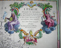 |
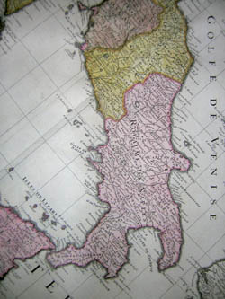
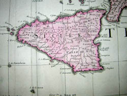
Map of Italy, including Sicily, Sardinia, Corsica, part of the Mediterranean Sea, and portions of the neighboring countries of Slovenia, Albania, Montenegro, Bosnia and Croatia. A Baroque cartouche, drawn and engraved by Charles Simonneau, depicts two seated female figures and putti. The woman on the left holds an incense burner, the one on the right rests one arm on a book while holding a tall crucifix, and with the other hand holds what appears to be a glowing goblet. At the bottom, a putto places a bishop’s miter upon another. The map comes from a relatively early de L’Isle atlas. Later editions were issued by the Buaches, de L’Isle’s successors, and by J.A. Dezauche, who printed a version in 1809.
Guillaume de L' Isle, appointed Royal Geographer in 1718, was the leading French cartographer of the early 18th century, and certainly among the most influential. He was known for his prolific output--over 100 maps--and his exceptional accuracy. From his first atlas, published at age 25, De L’Isle made an effort, unprecedented in his era, to base his work on verifiable, current data and to correct prevalent fallacies, such as the depiction of California as an island. His maps and atlases were frequently reissued after his death by Philippe Buache, Phillippe’s nephew Jean Nicolas Buache, and J.A. Dezauche. The Amsterdam publishers Covens and Mortier also reissued de L’Isle maps.
Cartouche: L’ Italie Dressee sur les Observations De Mrs. De l’Academie Royale des Sciences sur celles du R.P. Riccioli de la Compagnie de Jesus, et autres Astronomes du pays, et sur plusieurs autres memoires. Par G.De L’Isle Geographe A Paris Chez L’Auteur sur le Quai de l’Horloge Avec Privilege du Roy pour 20 ans. M.D.CC. [Italy based on the observations of the Gentlemen of the Royal Academy of Sciences, on those of R.P. Riccioli from the Jesuit Society, and other astronomers of the nation, and on many other accounts. By G. De L’Isle, Geographer, Quai de l’Horloge, Paris, with privilege from the King for 20 years. 1700.]
Reference:
Potter, Jonathan. Collecting Antique Maps: An Introduction to the History of Cartography. London: Jonathan Potter, 1999. pp. 48, 102-103, 106.