Georg Christoph Eimmart (1638-1705) (after)
Planisphaerium Coeleste: Secundum Restitutionem Hevelianamet Halleianam [Celestial
Planisphere According to the Restoration of Hevelius and Halley]
Possibly from Atlas Major
R. & J. Ottens, Amsterdam: c. 1772
Hand-colored engraving
20.5 x 25.5 inches, overall
20 x 22.5 inches, plate mark
Sold, please inquire as to the availability of similar items.

Double Hemisphere Constellation Chart
R. & J. Ottens, Amsterdam: c. 1772
R. & J. Ottens, Amsterdam: c. 1772
This item is sold. It has been placed here in our online archives as a service for researchers and collectors.
- Please inquire as to the availability of similar items currently in stock, or use the navigation bar above to browse our site for currently available items.
- Find guidelines for the use of images from georgeglazer.com.
- To see more archived items, view our directory.
- Find information about selling your art and antiques.

 |
 |
 |
 |
 |
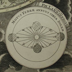 |
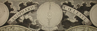
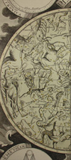
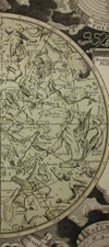
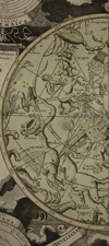
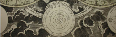
Double hemisphere celestial map, showing constellations of the northern and southern hemispheres, in original color with green-tinted hemispheres and some stars colored yellow. Most of the constellations are depicted as figures according to classical mythology, with more recently named ones in the southern hemisphere rendered as scientific instruments. The outer borders are decorated with six inset diagrams among clouds, showing the planetary models of Tycho Brahe, Ptolemy, and Copernicus, as well as the illumination of the moon by the sun, the revolution of the earth around the sun, and the effect of the moon on tides. A key to magnitudes of stars is in the center. The selection and style of the constellations were based upon Firmamentum Sociescianum sive Uranographia (1687) by the Polish astronomer Johannes Hevelius, whose name is noted in the subtitle of the chart. The subtitle indicates that the chart also draws on the work of Edmund Halley, the astronomer for whom Halley’s Comet is named. The format of the map derives from Georg Christoph Eimmart, a Nuremberg astronomer.
The map offered here was published in Amsterdam c. 1772 by R. & J. Ottens. Various firms in Amsterdam, Nuremberg and Augsburg published double hemisphere constellation charts similar to the offered example, at least from 1705 into the 1770s. One version, published by Homann in 1705, bears the inscription, “Opera G.C. Eimmarti. prostat in Officina Homanniana,” meaning, “Work of Georg Christoph Eimmart offered for sale by the Homann Workshop.” Scholar Robert Harry Van Gent notes the existence of a similar plate published earlier by Frederick de Wit, about 1696.
The Ottens print and map publishing firm was founded by Joachim Ottens, a copper engraver. After his death in 1719, his widow and his two sons Reinier (1698-1750) and Josua (1704-1765) Ottens continued the business. In 1750, Reinier died and was succeeded by Josua's son, Reinier II (1729-1793). The Ottens firm is best known for their multi-volume atlases of Dutch maps assembled to order such as Atlas Major. They also produced city and country maps and reissued maps produced by earlier Dutch cartographers.
References:
Dekker, Elly, et al. Globes at Greenwich: A Catalogue of the Globes and Armillary Spheres in the National Maritime Museum, Greenwich. London: Oxford University Press and the National Maritime Museum, 1999. p. 327.
Stoppa, Felice. “Georg Christoph Eimmart.” Atlas Coelestis. http://www.atlascoelestis.com/eimmart%201705.htm (10 May 2006).
Tooley, R.V. Maps and Map-Makers. New York: Bonanza Books, 1949. p. 27.
van Gent, Robert Harry. “The Atlas Coelestis (1742) of Johann Gabriel Doppelmayr.” 3 December 2004. http://www.phys.uu.nl/~vgent/doppelmayr/doppelmayr.htm. (10 May 2006).