Franklin Globes
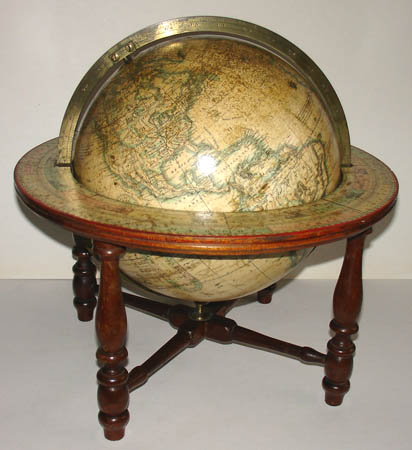
10-Inch Terrestrial Table Globe
Moore & Nims, Troy, New York: c. 1858-68
15 inches high; 14 inches diameter overall
Sold, please inquire as to the availability of similar items.

10-Inch Terrestrial Table Globe
Moore & Nims, Troy, New York: c. 1858-68
Moore & Nims, Troy, New York: c. 1858-68
This item is sold. It has been placed here in our online archives as a service for researchers and collectors.
- Please inquire as to the availability of similar items currently in stock, or use the navigation bar above to browse our site for currently available items.
- Find guidelines for the use of images from georgeglazer.com.
- To see more archived items, view our directory.
- Find information about selling your art and antiques.
 Top |
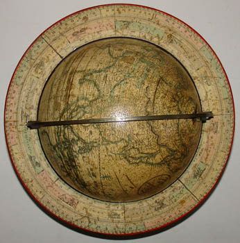
 Cartouche |
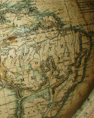 Detail of South America |

Detail of Eastern and Midwestern United States |
The terrestrial globe is surmounted by an arrow pointer and printed hour circle, within a calibrated full brass meridian and circular horizon band with engraved paper calendar and zodiac. The globe is raised on a hard-wood stand with four turned legs ending in spade feet, joined by a turned X-form stretcher. Oceans and geographic entities are cream colored, with some light green and dark green outlining.
North and South Dakota are shown prior to statehood (1891) with the area east of the Missouri River labeled “Dacota” and the rest included with present-day Nebraska and the Yellowstone area as “Nebraska.” Oklahoma is called “Indian Territory,” and Alaska is “Russian America.” Historical and commercial data of interest to mid-19th century Americans is printed on the oceans. For example, a dotted lines indicates routes taken by the U.S. Navy expedition to explore the Pacific Ocean led by Lt. Charles Wilkes from 1838 to 1842. A dotted line labeled “New York to Aspinwall” shows the Pacific Mail route from New York to San Francisco via Panama established by William Aspinwall. The recently installed Atlantic Cable between Britain and the U.S. is shown as “Submarine Telegraph Cable." There is also an oval analemma colored pink and green.
Franklin Globes were produced throughout the second half of the 19th century in Troy, New York, by a succession of globe makers and booksellers: Merriam & Moore, Merriam Moore & Co., Moore & Nims, H.B. Nims & Co., Nims & Knight, and back to H.B. Nims & Co. in the 1890s. They were available in the six, ten, twelve, sixteen, and thirty-inch diameters, with a variety of bases, generally in iron or wood and often reflecting the prevailing Victorian decorative arts style of the period.
Circular Cartouche: THE FRANKLIN/ TERRESTRIAL/ GLOBE/ 10 INCHES IN DIAMETER CONTAINING ALL THE/ Geographical Divisions/ & POLITICAL BOUNDARIES/ to present date/ carefully compiled from the best Authorities/ MOORE & NIMS/ TROY N.Y.
References:
Glover, Bill. "History of the Atlantic Cable & Submarine Telegraphy Cable Timeline: 1845-1900." Atlantic Cable. 5 November 2005. http://atlantic-cable.com/Cables/CableTimeLine/index1850.htm.
Levy, D.A. “William Henry Aspinwall.” 14 February 2004. The Maritime Heritage Project.http://www.maritimeheritage.org/vips/aspinwall.htm (2 September 2008).
Rochester, Junius. “Charles Wilkes.” HistoryLink.org. 17 February 2003. http://www.historylink.org/essays/output.cfm?file_id=5226 (2 September 2008).
Warner, Deborah Jean. "The Geography of Heaven and Earth." Rittenhouse Journal of the American Scientific Instrument Enterprise. Vol. 2, Nos. 2 & 3, 1987. pp. 63-64, 88-89.
Yonge, Ena L. A Catalogue of Early Globes, Library Series No. 6. American Geographical Society, 1968. p. 53.