William Bardin (c. 1740-1798) (maker)
Gabriel Wright (d. 1803-04) (cartographer)
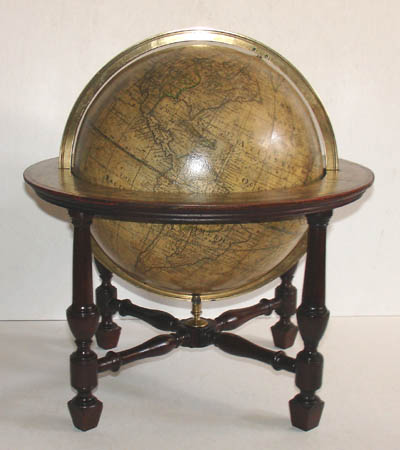
9-Inch Terrestrial Table Globe
W. Bardin, London: 1782 (original publication)
Harrison & Co., London: 1783 (republication)
Mahogany stand with four turned legs and cross stretcher
13.5 inches high, 12.5 inches diameter
Sold, please inquire as to the availability of similar items.

9-Inch Terrestrial Table Globe
William Bardin, London: 1783
William Bardin, London: 1783
This item is sold. It has been placed here in our online archives as a service for researchers and collectors.
- Please inquire as to the availability of similar items currently in stock, or use the navigation bar above to browse our site for currently available items.
- Find guidelines for the use of images from georgeglazer.com.
- To see more archived items, view our directory.
- Find information about selling your art and antiques.
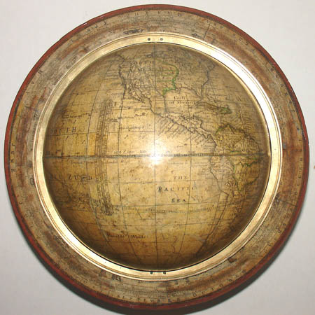
Top view showing horizon band and the Western Hemisphere.
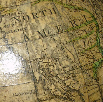
The West Coast of North America is labeled "New Albion." |
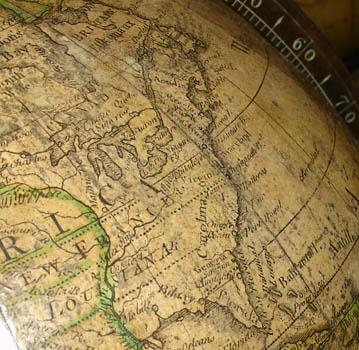
The Mississippi River area is labeled "New France, Louisiana." |
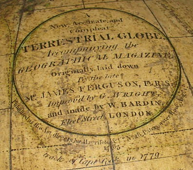
Cartouche, with part of the "track of Capt Cook in 1779." |
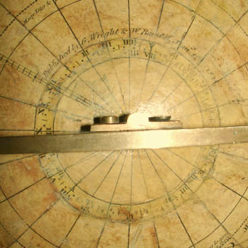
Publication information around the South Pole hour circle. |
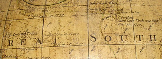
When Gabriel Wright updated the cartography of this globe, he added the routes of British explorers Admiral Anson and Captain James Cook. The detail above of the "Great South" Sea (South Pacific) shows the routes of "Anson's Track" (labeled at left with a dotted line running horizontally across the words "Great South") and the spot where "Capt Cook was kill'd Feb'y 14, 1779" in a tragic misunderstanding with the native islanders (labeled at right).
The terrestrial globe in calibrated full brass meridian, within a circular horizon band with engraved paper calendar and zodiac, raised on a turned mahogany stand with four legs joined by a cross stretcher. As the cartouche notes, the cartography originated with the globe maker James Ferguson (1710-76) as modified by Gabriel Wright (d. 1803-04) in 1782. Wright updated the cartography and added the routes of Captain James Cook's voyages of exploration between 1769 and 1779, along with the location where Cook was killed in Hawaii. The northwestern portion of North America is labeled New Albion; the Midwestern portion of the present-day United States, then claimed by the French, is called New France/Louisiana.
Admiral Anson's voyage around the world in the 1740s is also indicated. Australia is labeled New Holland and Tasmania is shown as a peninsula. The oceans are labeled The Icy Ocean (North Pole), Ice Sea (South Pole), The Ethiopic Ocean (South Atlantic), The Southern Ocean, The Indian Sea, The Eastern Ocean, Great South or Mar del Zud, The Pacific Sea, and The Western or Atlantic Ocean. Antarctica is not depicted, though "Islands of Ice" and "Mountains of Ice" are indicated in the general area. "Variable Winds" with wind arrows are indicated between the tropics. There are two tables for the Monsoons in "The Indian Sea" and "The Eastern Ocean."
Another example of this globe, on a nearly identical stand, is in the collection of the National Maritime Museum at Greenwich, England, and is listed and pictured in the catalogue of the collection, Globes at Greenwich. The museum also has a companion celestial globe by Bardin and Wright produced at the same time and a later version of the terrestrial globe produced after 1800 with the same cartography and different cartouche.
The Bardin family was among the greatest globe makers in London from the late eighteenth through the early nineteenth century. The patriarch of the family, William Bardin (d. 1798), began globe production in the 1780s. His globes were also sold by other instrument makers. This William Bardin globe, dated 1783, is among his earliest. It was issued by Harrison & Co., printers and booksellers, as a promotional gift to go with William Frederick Martyn's The Geographical Magazine, or a New, Copious, Compleat and Universal System of Geography, which Harrison published in parts beginning January 1, 1782. Read more about Bardin globes in our Guide to Globe Makers.
Circular Cartouche: A/ New, Accurate, and/ Compleat/ TERRESTRIAL GLOBE,/ Accompanying the/ GEOGRAPHICAL MAGAZINE/ Originally laid down/ By the late/ Mr. JAMES FERGUSON, F.R.S./ Improv’d by G. WRIGHT,/ and made by W. BARDIN/ Fleet Street, LONDON/ Published as the Act directs by Harrison & Co. No. 18 Pasternoster Row Aug't 1st/ 1783
Inscription South Pole: Published by G. Wright & W. Bardin Jan'y 1st 1782References:
Dekker, Elly, et al. Globes at Greenwich: A Catalogue of the Globes and Armillary Spheres in the National Maritime Museum, Greenwich. London: Oxford University Press and the National Maritime Museum, 1999. GLB0169, pp. 262-263, GLB0093, p. 265.
Dekker, Elly and van der Krogt, Peter. Globes from the Western World. London: Zwemmer, 1993. pp. 114-116.
"Terrestrial table globe (GLB0169)." National Maritime Museum. http://www.nmm.ac.uk/collections/explore/object.cfm?ID=GLB0169 (28 July 2010).