John Senex (fl. 1690-1740) (after)
Henry Hulsbergh (d. 1729) (engraver)
A Map of the World Corrected from the Observations Communicated to the Royal Societys [sic] of London and Paris by John Senex F.R.S.
John Senex, London: 2nd Quarter 18th C.
Hand-colored engraving
23.25 x 42.25 inches image to ruled border
26.25 x 45.75 inches overall
Sold, please inquire as to the availability of similar items.

A Map of the World
Large Double Hemisphere Map by John Senex
Large Double Hemisphere Map by John Senex
This item is sold. It has been placed here in our online archives as a service for researchers and collectors.
- Please inquire as to the availability of similar items currently in stock, or use the navigation bar above to browse our site for currently available items.
- Find guidelines for the use of images from georgeglazer.com.
- To see more archived items, view our directory.
- Find information about selling your art and antiques.
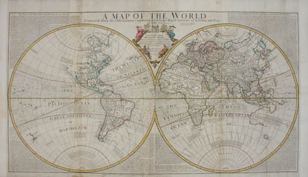
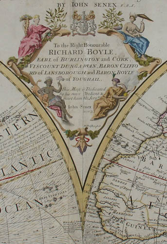
Large British double hemisphere map of the world of the early Georgian period. Executed in outline color, with full color of the cartouche. It is decorated with allegorical female figures representing “the four continents” as the world was perceived at the time: America, Africa, Asia and Europe. California is shown as an island as was believed by many at the time, though in later versions, Senex corrected it to show it attached to the mainland. Surrounding the map are lengthy scientific texts by Sir Isaac Newton on “The Theory of the Tides” and Edmond Halley on “An attempt to assign the Physical cause of the Trade Winds and Monsoons.” The cartouche dedicates the map to Richard Boyle, Lord Burlington at Chiswick and is surmounted by his coat of arms with the motto, “Vivit post funera virtus” [Virtue lives after death].
The map was originally co-published by John Senex and his then-partner John Maxwell in 1711, with both their names in the cartouche, and reissued with variations several times until around 1750. In this printing, Maxwell’s name has been scrubbed from the plate, though is still faintly visible. While Senex is identified in the title as F.R.S. (Fellow of the Royal Society), he did not receive that honor until 1728 (notwithstanding that the map is dated 1725). The map was available as a part of Senex’s atlases and also separately issued. Another example of this map is in the collection of the National Library of Australia, which has placed an image of it online (see References below).
John Senex began as an astronomer and map maker, and was also an engraver, publisher, surveyor and geographer to Queen Anne. He was admitted to the Royal Society in 1728. He was also one of the early globe makers in Britain and produced pocket globes as well as larger globes in collaboration with Charles Price (fl. 1697-1733) from 1706 to 1710, and thereafter under his own name until his death in 1740. Senex's widow continued globe production until 1755.
Henry Hulsbergh is the Anglicized name of Hendrick Hulsberg, a Netherlandish engraver, active in London, who died in 1729. He engraved a number of maps for John Senex, and also engraved many architecturals for such works as Colen Campbell's Vitruvius Britannicus (1725).
Additional inscriptions:
“To the Right Honourable Richard Boyle, Earl of Burlington and Cork, Viscount Dungarvan, Baron Clifford of Lansborough and Baron Boyle of Youghail. This Map is Dedicated by his Most Obedient & Most Humble Servts. John Senex.” (title)
“Sold by I. Senex at the Globe against St. Dunstans Church in Fleetstreet London 1725.” (upper right, beneath title)
References:
“A Map of the World [cartographic material]…” National Library of Australia. http://nla.gov.au/nla.map-nk4556 (12 September 2008).
Leighly, John. California as an Island. San Francisco: Book Club of California, 1972. p. 156.
Whitfield, Peter. The Image of the World: 20 Centuries of World Maps. San Francisco: Pomegranate Artbooks, 1997. pp. 110-111.