Dillon Lauritzen (artist)
Phil Townsend Hanna (editor)
Joseph J. Hill (compiler)
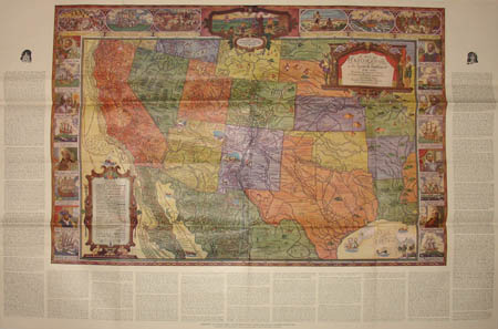
A Map of Exploration in the Spanish Southwest 1528-1793
Automobile Club of Southern California: 1932
Color-process print, folding as issued
28 x 42 inches, overall
Sold, please inquire as to the availability of similar items.

Map of Exploration in the Spanish Southwest
Pictorial Map by Dillon Lauritzen: 1932
Pictorial Map by Dillon Lauritzen: 1932
This item is sold. It has been placed here in our online archives as a service for researchers and collectors.
- Please inquire as to the availability of similar items currently in stock, or use the navigation bar above to browse our site for currently available items.
- Find guidelines for the use of images from georgeglazer.com.
- To see more archived items, view our directory.
- Find information about selling your art and antiques.

 |
 |
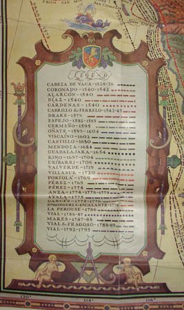
Colorful map of the southwestern portion of the U.S. and the northern portion of Mexico, from the Pacific Coast in the west to Missouri, Arkansas and Louisiana in the east. The routes of 30 explorers of the region between 1528 and 1793 are indicated on the map (such as Drake, La Perouse, Diaz, de Vaca). The border is decorated along three sides with illustrations related to the explorations, including portraits of the explorers, their ships, or events that occurred in connection with their journeys. On the map itself are small illustrations of wildlife such as bison (buffalo), trees, people and tepees. Surrounding the map is a text with brief historical texts about the explorers. The map was produced as a supplement to Touring Topics, a monthly magazine focused on automotive tourism published by the Automobile Club of Southern California.
Dillon Lauritzen was an artist and illustrator living in Los Angeles, who also worked in the movie industry as a cartoonist. During his lifetime he exhibited at the Art Institute of Chicago. The Art Directors Club of Los Angeles presents a Dillon Lauritzen Memorial Award for fine art in his honor.
Full publication information: “Supplement to Touring Topics, Volume Twenty-Four, Number One, January, Nineteen Thirty-Two. Copyright in Nineteen Thirty-One by the Automobile Club of Southern California.”