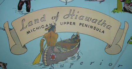
Land of Hiawatha: Michigans Upper Peninsula
Upper Peninsula Development Bureau, Marquette, Michigan: 1935
Color-process print
20.5 x 37.75 inches, map
22 x 39.5 inches, overall
Sold, please inquire as to the availability of similar items.

Land of Hiawatha: Michigans Upper Peninsula
1935 Poster Pictorial Map
1935 Poster Pictorial Map
This item is sold. It has been placed here in our online archives as a service for researchers and collectors.
- Please inquire as to the availability of similar items currently in stock, or use the navigation bar above to browse our site for currently available items.
- Find guidelines for the use of images from georgeglazer.com.
- To see more archived items, view our directory.
- Find information about selling your art and antiques.


 |
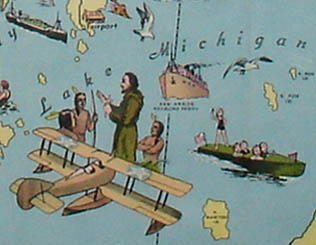 |
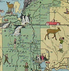
Large poster-sized pictorial map of Michigan’s Upper Peninsula, with parts of Lake Superior, Lake Huron and Lake Michigan. The map is decorated with dozens of illustrations, promoting the region as a tourist destination with ample recreational opportunities. It features the locations of national and state forests, game refuges, fish hatcheries, state and county parks and airports and landing fields. Interstate highways, state roads and county roads are indicated. The illustrations include a few references to the history of the region, such as a lumberjack, Native Americans in canoes, a Catholic missionary and an antique airplane. The focus, however, is on enjoyment of the outdoors: wildlife such as moose, bears, deer, and ducks, and people engaged in hunting, fishing, sailing, swimming, horseback riding, skiing, tennis, golf and so forth. Lakes are shown in blue, Upper and Lower Peninsula counties in yellow with national and state forests in green. The rest of Michigan is in purple, a small slice of Canada indicated in white.
Copyright Notice: Copyright 1935. Upper Peninsula Development Bureau. George E. Bishop, Sec.-Mgr. Marquette, Michigan. Chicago Office, 332 So. Michigan Ave. Telephone Wabash 8381. (State of Michigan Cooperating).