Stephen J. Voorhies
Historic Long Island
New York: 1936
Photo-process print mounted on board
30.5 x 23.5 inches, including frame
Sold, please inquire as to the availability of similar items.

Historic Long Island
Stephen J. Voorhies, New York: 1936
Stephen J. Voorhies, New York: 1936
This item is sold. It has been placed here in our online archives as a service for researchers and collectors.
- Please inquire as to the availability of similar items currently in stock, or use the navigation bar above to browse our site for currently available items.
- Find guidelines for the use of images from georgeglazer.com.
- To see more archived items, view our directory.
- Find information about selling your art and antiques.
 |
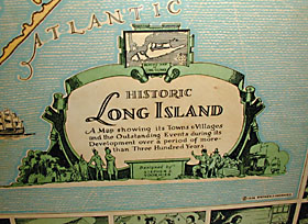 |
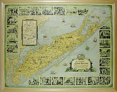
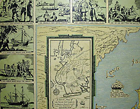
Decorative and historical map of Lond Island subtitled "A Map showing its Towns & Villages and the Outstanding Events during its Development over a period of more than Three Hundred Years." The central pictorial map has numerous illustrations of historic sites and events, with waters filled with sailing ships. It is surrounded by 23 inset illustrations of historical events, within an outer border with the names of "the thirteen tribes of Indians who were the first proprietors of Long Island." Also includes inset: "A Detail Map of the Dutch settlements on Western Long Island, Now the Borough of Brooklyn." Decorative cartouche with Native Americans and Pilgrims. Land mass is shown coloured in shades of yellow, waterways are in blue, and the historical border is green.