Manhattan Upper West Side Manuscript Map
New York City: 2nd Quarter 19th Century
Pen and ink and watercolor on paper
25.5 x 33 inches, overall
Sold, please inquire as to the availability of similar items.

Manhattan Upper West Side Manuscript Map
New York City: 2nd Quarter 19th Century
New York City: 2nd Quarter 19th Century
This item is sold. It has been placed here in our online archives as a service for researchers and collectors.
- Please inquire as to the availability of similar items currently in stock, or use the navigation bar above to browse our site for currently available items.
- Find guidelines for the use of images from georgeglazer.com.
- To see more archived items, view our directory.
- Find information about selling your art and antiques.
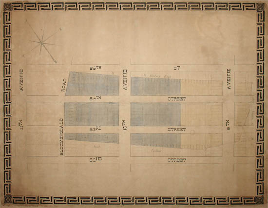
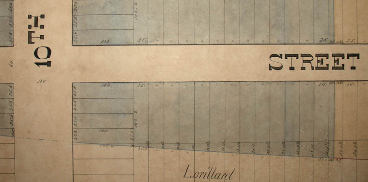

An original manuscript map of a portion of the Upper West Side of Manhattan in New York City. The map might have been drawn as early as the 1830s -- the approximate period shown based on land ownership and street names -- or in the next few decades thereafter as an historical record of how it was at that time. The unique hand-drawn and hand-lettered plat surveys four square blocks between Ninth Avenue (now Columbus Avenue) in the east to Eleventh Avenue (now West End Avenue) in the west, and from 82nd Street in the south to 85th Street in the north. There are two irregularly shaped shaded areas within the map -- one tinted blue and the other tinted yellow -- that include lot lines and dimensions. The diagonal edges of these shaded areas are labeled with surveying measurements. The surrounding properties are labeled with the names of their owners, Jacob Lorillard (1774-1838) and "W.W. Woolsey Esqr." -- William Walton Woolsey (1766-1839). There is an eight-pointed compass drawn in the upper left corner. The entire map is surrounded by a meticulously drawn neoclassical Greek key border with floral rosette designs in each corner. This design is consistent with dating the map in the second quarter of the 19th century.
During the period shown in the map -- likely the 1830s -- the Upper West Side was a rural area where wealthy New Yorkers had summer estates. Today, above 59th Street, Ninth Avenue becomes Columbus Avenue, Tenth Avenue becomes Amsterdam Avenue and Eleventh Avenue becomes West End Avenue. Between Tenth and Eleventh Avenues, the maps shows Bloomingdale Road, the name by which the northern section of Broadway was known, until it was renamed Broadway in 1899. Although both property owners shown on the map -- Jacob Lorillard and W.W. Woolsey -- died at the end of the 1830s, at least some of their holdings continued to belong to their estates for many years afterwards. For example, the New-York Historical Society has a map of the area that shows the William W. Woolsey Estate and Jacob Lorillard as property owners, which they have dated as circa 1847-1850, based on accompanying documentation. Property in Lower Manhattan belonging to the Estate of Jacob Lorillard was sold in 1846. Nonetheless, the map was likely of holdings before Woolsey died in 1839 inasmuch as it lists him as "W.W. Woolsey Esqr" rather than indicate his estate.
Jacob Lorillard and William Walton Woolsey were both prominent New Yorkers and major landowners during the early decades of the 19th century. William Walton Woolsey was an officer of the New York Chamber of Commerce and of the Manufacturing Society of New York City. He served on many boards of directors including Merchants' Bank and Eagle Fire Insurance Company, where he also was president. Jacob Lorillard, son of the founder of the Lorillard Tobacco Company, made his own fortune establishing a tannery in Lower Manhattan. He invested in real estate around the city and like Woolsey, served on boards of banking and insurance companies. Both men were also active philanthropists and served on boards and as officers of numerous charitable and civic organizations as well.
References:
Loorya, Alyssa et al. Phase IA Archaeological Documentary Study - West Village Houses/Whitehall Storage Project. New York: February 2008. Online at: http://nytelecom.vo.llnwd.net/o15/agencies/lpc/arch_reports/1042.pdf (26 June 2013).
"[Map of the area later bounded by 71st and 86th Streets, Columbus and West End Avenues, Manhattan, New York (N.Y.)]." WorldCat.org. http://www.worldcat.org/title/map-of-the-area-later-bounded-by-71st-and-86th-streets-columbus-and-west-end-avenues-manhattan-new-york-ny/oclc/84062340 (26 June 2013).