The Long Island Railroad Co.
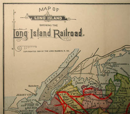
Map of Long Island Showing The Long Island Railroad
American Bank Note Co., New York: Copyright 1884
Color-printed engraving
White pebbled card covers dated 1891
13.5 x 26.75 inches, overall
Sold, please inquire as to the availability of similar items.

Long Island Residential and Vacation Map
Long Island Railroad, 1884
Long Island Railroad, 1884
This item is sold. It has been placed here in our online archives as a service for researchers and collectors.
- Please inquire as to the availability of similar items currently in stock, or use the navigation bar above to browse our site for currently available items.
- Find guidelines for the use of images from georgeglazer.com.
- To see more archived items, view our directory.
- Find information about selling your art and antiques.
 |
 |

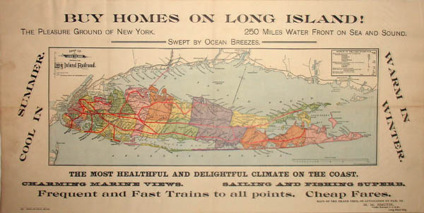
A map of Long Island, issued by the Long Island Railroad at the turn of the 20th century. Enticing slogans surround the map promoting the island as a residential location and vacation destination: “Buy Homes on Long Island! The Pleasure Ground of New York. 250 Miles Water Front on Sea and Sound. Swept by Ocean Breezes. Cool in Summer. Warm in Winter. The Most Healthful And Delightful Climate On The Coast. Charming Marine Views. Sailing and Fishing Superb. Frequent and Fast Trains to all points. Cheap Fares.”
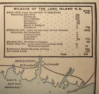
Towns are shown colored in shades of pink, green, purple, orange and yellow. Long Island Sound, the Atlantic Ocean and other bodies of water are colored blue. Long Island Railroad routes are shown in bold red and connecting railroads shown in black. A table in the upper left shows different lines and branches and their distances in miles including the Montauk Division, which terminated at Sag Harbor. There is a mileage scale lower right.
The map folds into white pebbled covers, imprinted in gold. The covers are dated 1891, though the copyright on the map remained 1884. There was, however, an updated and reissued version of the map published in 1891 by Sackett & Wilhelms Lithography Co., New York, with the same slogans but in different typefaces, and additional pictorial illustrations and decorative flourishes in the margins.
The copyright 1884 version offered here is discussed by historian David Yehling Allen in his books on Long Island and New York State maps. In the latter work he explains why the railroad produced the map:
There is a good reason why the Long Island Railroad was so heavily involved in promoting suburban real estate. Long Island has some of the earliest and best-known suburban developments in the country, and access to these new communities was by streetcar and railroad. “The route of the dashing commuter,” as the Long Island Railroad later liked to call itself, therefore had a strong financial interest in promoting this trend. Maps emphasizing rail connections were produced by both the railroad and by real estate developers (which often mentioned the proximity of their properties to a railroad station). They are an important source for studying the first phases of suburbanization in the United States.
Legend under title: "Copyrighted 1884 by the Long Island R.R. Co.”
Legend in Map: Eng’d by American Bank Note Co., New York
Legend Lower Left Margin: 38930 American Bank Note Co., New York."
Legend Lower Right Margin: “Maps of the Island Free, on Application by Mail to H.M. Smith, Traffic Manager, L.I.R.R., Long Island City.”
Cover Title: "Map of Long Island. Issued by the Long Island Railroad Co. 1891."
References:
Allen, David Yehling. Long Island Maps and Their Makers. Mattituck, NY: Amereon House, 1997. pp. 104-105.
Allen, David Yehling. The Mapping of New York State: A Study in the History of Cartography. 5 November 2011. http://www.dyasites.com/maps/nysbook/Chapter13b.htm (23 April 2012).