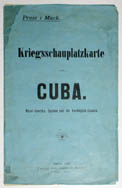
Kriegsschauplatzkarte, Von Cuba. Mittle-Amerika, Spanien und die Vereinigten-Staaten./ Cuba
[Theater of War Map of Cuba. Central America, Spanish and Combining States./Cuba]
Dietrich Reimer (Ernst Vohsen Successor), Wilhelmstrasse 29, Berlin: 1898 (1st ed.)
Color offset print folding into covers, as issued, 11 x 6.5 inches
18.5 x 21.25 inches printed border, text non-inclusive
21.75 x 24.25 inches, overall
Sold, please inquire as to the availability of similar items.

Map of Cuba, Spanish-American War
Dietrich Reimer, Berlin: 1898
Dietrich Reimer, Berlin: 1898
This item is sold. It has been placed here in our online archives as a service for researchers and collectors.
- Please inquire as to the availability of similar items currently in stock, or use the navigation bar above to browse our site for currently available items.
- Find guidelines for the use of images from georgeglazer.com.
- To see more archived items, view our directory.
- Find information about selling your art and antiques.

 |
 |
 |
 |
 |
 |
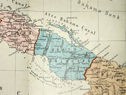
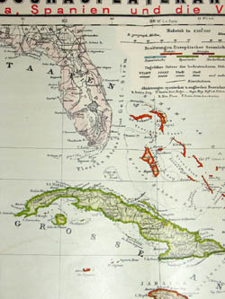
Folding two-part map showing both Cuba and the Caribbean area, printed the same year as the Spanish-American War, to show the Cuban theater of war. The Caribbean map shows the Antilles, Florida, and Central America with railroads, cities, and international holdings by the British, Danish, French, Spanish, and Dutch. An inset map of the Atlantic area shows distances in nautical miles for important trade routes. The map of Cuba depicts railways and provincial borders, with the various provinces in shades of red, green, yellow, and blue.
The Spanish-American War took place in 1898 and was fought primarily on two fronts: in the Spanish colonies of the Philippines and Cuba, with some fighting also taking place in Puerto Rico. The lead up to the war began with Cuban rebels, who by 1897 had the Spanish on the defensive. The rebel leader successfully lobbied the U.S. Congress to intervene and help defeat the Spanish. The U.S. officially declared war on Spain in April 1898 and the war was over by August 1898. With the signing of the Treaty of Paris, in December 1898, the U.S. gained most of Spain's colonies, including the Philippines, Guam and Puerto Rico. Cuba was granted independence.
For more information about Dietrich Reimer see our Guide to Globe Makers.
Reference:
"Spanish-American War." Wikipedia. 1 November 2005. http://en.wikipedia.org/wiki/Spanish-American_War (1 November 2005).