Tobias Conrad Lotter (Successor to Seutter Family)
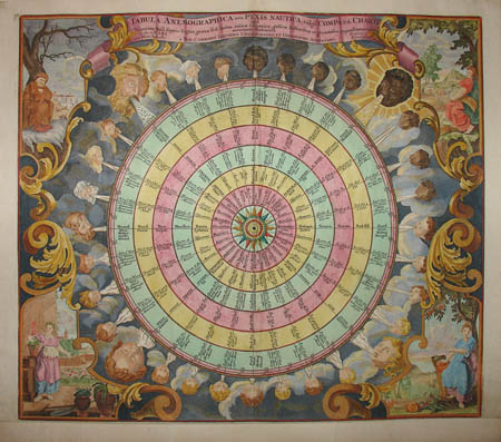
Tabula Anemographica
Augsburg, Germany: Mid 18th Century
Hand-colored engraving on laid paper
19.5 x 22.75 inches, image
21.75 x 24.75 inches, overall
Sold, please inquire as to the availability of similar items.

Tabula Anemographica
Tobias Conrad Lotter, Mid 18th C.
Tobias Conrad Lotter, Mid 18th C.
 |
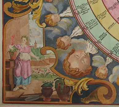 |
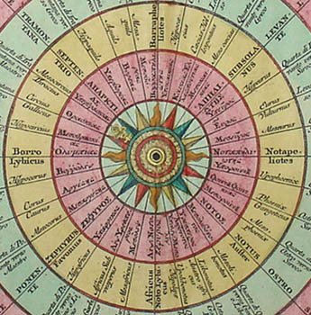
Dramatic wind chart with rich Baroque decoration featuring central compass of wind directions dividing the directional area into 32 sections, and with text in six languages (German, Dutch, Italian, Latin, French and Spanish). Surrounding the compass are 31 small cherub heads arranged in successive ages from young to old, and four large heads, blowing winds on the compass and seasons. The spandrels of the print are decorated with allegorical representations of the four seasons.
The Seutter family of cartographers were, together with the Homann family, the most renowned and prolific map makers of 18th Century Germany, the leading center of atlas production at that time. Georg Matthaeus Seutter, Geographer to the Imperial Court, founded the family business and was later joined by his son, Albrecht Carl Seutter, who eventually succeeded to the business. The Seutters engaged the talented engraver Tobias Conrad Lotter to produce maps for various atlases. Lotter eventually took over the Seutter cartography business. This map of the winds, bearing Lotter's name, is typical of the bold engraving with rich Baroque motifs of the Seutter/Lotter firms.
Tobias Conrad Lotter was a cartographer and engraver based in Augsburg. In 1755, he collaborated with Tobias Lobeck on Atlas Geographicus Portatilis. In the mid 18th century he engraved maps for atlases produced by the Seutter cartography firm founded in 1707 by his father-in-law, Georg Matthias Seutter (1678-1757). Seutter had been trained by Johann Baptist Homann, another prominent Augsburg map producer, and served as geographer to the court of Charles VI. Within about a year after Seutter's death in 1757, Lotter took over the business and continued to issue updated versions of the maps over the next two decades under his own name. The Seutter family of cartographers were, together with the Homann family, the most renowned and prolific map makers of 18th century Germany, the leading center of atlas production at that time. Georg Matthaeus Seutter, Geographer to the Imperial Court, founded the business and was later joined by his son, Albrecht Carl Seutter, who eventually succeeded him.
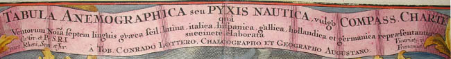
Full Cartouche: TABULA ANEMOGRAPHICA seu PYXIS NAUTICA, vulg'o COMPASS. CHARTE qua Ventorum Noia feptem linguis graca fcil latina, italica, hifpanica, gallica, hollandica et germanica repafentantur Succincte elaborata A TOB CONRADO LOTTERO, CHALCOGRAPHO ET GEOGRAPHO AUGUATANO. Cu Gr. Et Pr, S.R.I. part. Rheni, Svev et Jur. Vicariatg, in Franconici
Reference:
"Historical Maps Germany." Artelino Art Auctions. 2001-2004. http://www.artelino.com/articles/historical_maps_germany.asp (3 August 2004).