


Description
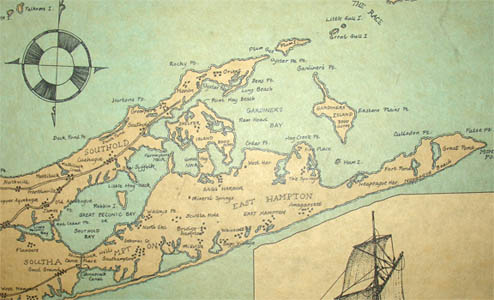
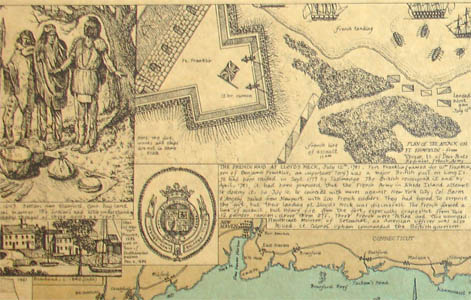
The map is printed in shades of black, tan and aqua on buff colored paper and is mounted on board, and in a simple wooden frame, without glass, as originally issued. Promotional material about the artist from the time the map was produced is attached to the back of the frame. It is apparently scarce, with just two known copies in a public collection, that of the Brooklyn Historical Society.
Ronald Toelke is an illustrator and graphic designer based in Chatham, New York. He graduated from SUNY Buffalo. By at least 1970, he began to produce educational maps that dealt with important aspects of American history in a manner his publishing company Selar Art Company described as “authentic historically and attractive for decorating purposes.” These included Manhattan Island in 1776 (1972), The Shaker Communities in America (1973) and An Historical Portrait of Long Island (1974). In 1982 he opened Toelke Associates with his wife Barbara Kempler-Toelke, providing publication design services, illustrations and map graphics. He remains involved with publication projects based on American history, having helped compile Waterways of War: The War of 1812 (2013) and a traveler’s guidebook to the Great Lakes Seaway Trail related to that war. He also is among the founders of the magazine Columbia County History & Heritage, which he and his wife design and produce.
Full publication information: Drawn and engraved by Ronald Toelke. © Done in the month of March, 1974 – Chatham NY.
Condition: Generally very good, with usual and expected wear, toning and soiling.
References:
“Five questions for Sept. 26, 2013: Ron Toelke.” Troy Record. 26 September 2013. http://www.troyrecord.com/general-news/20130926/five-questions-for-sept-26-2013-ron-toelke (29 October 2014).
Selar Art Co. Inc. promotional material. Chatham, NY, c. 1970s.
Toelke, Ron. “Arma Virumque Cano.” Columbia County Historical Society. Spring 2011. p. 10. Online at http://www.nycivilwar150.org/reenactors/Toelke_CW_article.pdf (29 October 2014).