


Description
As is customary for Albert Richard football maps, the backside of the 1939 map has several illustrations of Albert Richard’s seasonal jackets and coats and related sales information. In the center is a list — “The Albert Richard All-American Team” from 1938 — with an invitation to the public to mail their votes to the company for 1939’s All-Americans. This particular example of the 1939 map has the name Strouss-Hirshberg’s Men’s Furnishings, Youngstown, Ohio, imprinted on the back — apparently the retail store gave it away as a promotion.
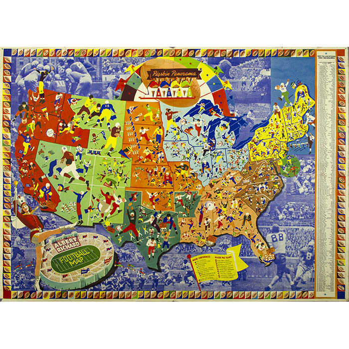
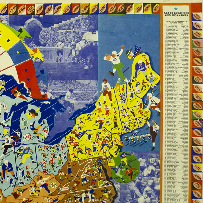
Albert Richard Co. published all-America football map posters for the five years 1938, 1939, 1940, 1941, and 1946, each with a different design by F.E. Cheeseman, that incorporated pertinent information. An additional edition (the sixth map in the series) was published in 1950, drawn by G.E. Smith. Each of the Cheeseman maps is illustrated with stylized Art Deco pictures in bold bright colors, packing a great deal of information into the design. Albert Richard — a division of Fried Ostermann Company in Milwaukee — manufactured men’s and boys’ outerwear and issued these maps as promotions; the backside of each map is fully illustrated with examples of the line of Albert Richard’s seasonal jackets and coats for that year and information about them. The map posters were apparently given away either by Albert Richard or by some of the regional retail clothing stores that sold its menswear. Indeed, Albert Richard placed ads in publications such as Boys’ Life magazine with a coupon to mail in for a free copy of the map poster: “You’ll want to hang it in your room for all your friends to admire.” During World War II, Albert Richard issued two other promotional maps by Cheeseman: Patriotic Panorama of the United States (1942) and Aviation Cavalcade (1944).
Stephen Hornsby illustrates the 1938 Albert Richard football map — the first in the series — with a double-page spread in his 2017 history of American pictorial maps, classifying it as among those that “demonstrated the importance of pictorial mapping for education and instruction.” An example of the 1941 Albert Richards football map belonging to the Library of Congress is described in Eyes of the Nation, a book about the Library collection:
This pictorial map demonstrates how popular football had become by the beginning of World War II. With a primary emphasis on the collegiate side of the sport, with team nicknames, 1940 season records, and major conference championships, it also documents the major professional clubs — only ten at the time. The map carries the endorsement of the noted sports writer Grantland Rice, and reports his selections for the 1940 All-America team.
Condition: Generally very good with the usual overall light toning, handling, wear, soft creases.
References:
“Football Map Advertisement.” Boys’ Life. October 1938. p. 24. Online at Google Books. https://books.google.com/books?id=aGV_FgxvN08C&pg=PA24 (14 August 2020).
Hornsby, Stephen J. Picturing America: The Golden Age of Pictorial Maps. Chicago: University of Chicago Press, 2017. pp. 79, 114-15.
Virga, Vincent, Alan Brinkley, and Curators of the Library of Congress. Eyes of the Nation A Visual History of the United States. New York: Knopf, 1997, pp. 300-301.


