Click main image below to view enlargements and captions.

Map, New York City, Metropolitan Area, New York World’s Fair, Vintage Print, c. 1939

$3,750

Map of New York World’s Fair 1939 and Metropolitan Area
New York: c. 1939
Color process print
40 x 40 inches
$3,750

Rare large wall map of New York City centered on the location of the 1939 World’s Fair in Flushing Meadows, Queens, which is highlighted in a cream color. The city’s five boroughs are rendered in detail, showing city blocks and piers delineated in tints of black. Parts of Bergen County, New Jersey; Westchester County and Long Island are also shown, but with major roads only. Shaded concentric circles indicated the progressive radius in miles from the site’s center at 1, 3, 6, 10, 15 and 21 miles. A large inset map within an octagonal border shows a detail of Flushing Bay, the fairgrounds, and surrounding roads and railroad lines. Roads are indicated in black, transit routes in red, yellow and green. An Art Deco style compass rose is centered below the inset map. Bodies of water are blue and land is tan. A grid of gray longitude and latitude lines covers the entire map, intersecting with a red and black striped border. The title is printed in large, drop-shadow Art Deco style lettering across the bottom. In the lower right is a union emblem indicating it was published in New York.

Product Description Continues Below

Description

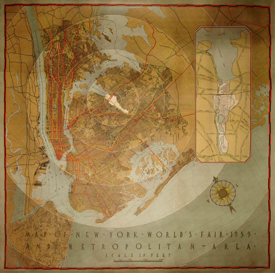
The New York World’s Fair of 1939 and 1940 was the largest and most spectacular exposition that had ever been held in the United States, surpassing all prior international fairs in terms of size, scope and number of exhibitors. It was promoted by a massive publicity campaign and set attendance records, with 45 million visitors during its two seasons — the best-attended event of the first half of the 20th century. To create the Flushing Meadows fairgrounds, the Corona city dump and some 1,200 acres of swamp were transformed into new buildings, roads and lakes — a major engineering feat that remains one of the largest land reclamation projects ever undertaken in the eastern United States. This map promotes the newly constructed destination along with the city as a whole by showing it as a central and accessible area.

Emblem imprinted lower right corner: S.A. No. 1 Union Label. New York Registered 92.

Condition: Generally very good with the usual overall minor toning, wear, soft creases, handling. Professionally backed on linen to restore tear into image, stable and unobtrusive.

Reference:

Weglein, Jessica, et al. New York World’s Fair 1939 and 1940 Incorporated Records 1935-1945. MssCol 2233. New York: New York: New York Public Library Manuscripts and Archives Division. June 2008. p. vii. Online at: http://www.nypl.org/sites/default/files/archivalcollections/pdf/nywf39fa_0.pdf (20 August 2013).

Additional information

Century

20th Century