Click main image below to view enlargements and captions.

Map, England and Wales, Antique Print, Covens & Mortier, Amsterdam, Mid 18th Century

$975

Regni Angliae et Walliae Principatus Tabula
[Picture of the Kingdom of England and Wales]

Covens and Mortier, Amsterdam: Mid 18th Century
Hand-colored copperplate engraving
22.5 x 25.25 inches, overall
20.25 x 23.25 inches, plate mark
$975

Map of England and Wales, also including the Isle of Man and the coasts of a portion of Scotland, Ireland, and France, which the full title states is divided into 52 regions and shows the British shires. The elaborate cartouche depicts allegorical figures and symbols of the British reign as if floating in the clouds encircled by cherubs. Seated before the title panel, with the arms of England showing three lions and a large crown, are a warrior representing King William, a woman holding a large gold crucifix, and a queen, possibly the female allegorical figure Britannia (though Britannia is traditionally shown in military garb). At the top of the cartouche, the royal arms are supported by the lion and the unicorn, symbols of England and Scotland, a convention adopted in 1603. Two compass roses rendered in the shape of a royal orb appear on either side of the British mainland. Distance scales are provided in four forms of measurement, a key explains the cartographic symbols, and all labeling is in Latin.

Product description continues below.

Description

Covens and Mortier was an Amsterdam firm formed in 1721 by Johannes Covens in partnership with the heirs of Pierre Mortier. Mortier, a Frenchman, had established a publishing house in Amsterdam by around 1685 and published or reissued maps by some of the great French and Dutch mapmakers of the late 17th and early 18th centuries, including Guillaume de L’Isle, Carel Allard and Jan Jansson. After Mortier’s death in 1711, the family continued the business and then joined with Covens. Covens and Mortier issued several atlases, including its major work Atlas Nouveau, published in nine folio volumes between 1711 and 1760. The firm also issued world and continent maps. Regni Angliae et Walliae… is variously credited by different sources as being after de L’Isle or Allard.

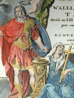
Cartouche: “REGNI ANGLIÆ et WALLIÆ PRINCIPATUS TABULA, Divisa in LII Regnonis, Anglice Shire dictas, præ coeteris correcta et edita/ per/ I. COVENS et C. MORTIER AMSTELO-BATAVUM. cum Privil. Potentiss. D. D. Ordinum/ Hollandice e Westfrifice.”

Condition: Generally very good with only minor wear. Some folds as issued, professionally flattened.

Reference:

Potter, Jonathan. Collecting Antique Maps: An Introduction to the History of Cartography. London: Jonathan Potter Ltd., 1988, rev. 1999. pp. 56, 102.

Additional information

Century

18th Century