


Description
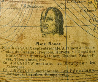
The unusual, probably unique feature of the globe is the inclusion of five illustrations representing different races by a portrait head placed in proximity to where each is indigenous. According to the standard categories of the day, they are identified mostly by color: Race Rouge, Race Blanche, Race Noire, Race Jaune and Malais (Red Race, White Race, Black Race, Yellow Race and Malay). Beneath each illustration, a caption lists the nationalities and where in the world they are found.
In North America, the Upper Midwest is labeled “Sioux Indiens” and Northern Mexico is labeled “Apaches.” The Antarctic is outlined, though not as recognized today as the correct coastline. The Belgian Congo is shown in Africa and St. Petersburg in Russia, dating this globe to between 1908 and 1914. Around 1924, a third (and probably final) edition of the globe was produced with updated geographical information.
L. Windels was active in Brussels during the first quarter of the 20th century, apparently only producing a 6-inch version and a 12-inch version of this ethnographic terrestrial globe.
Cartouche: GLOBE TERRESTRE/ 2me Édition/ à l’Échelle de 1/40,000,000/ (1 millimétre par 40 Kilomètres)/ dressé d’après les dernières données des/ GÉOGRAPHES LES PLUS RÉPUTÉS/ avec illustrations ethnographiques.
Additional legends below cartouche:
SIGNES CONVENTIONNELS/ Villes capitals/ Autres villes importantes/ Limites des états/ Limites des terres/ Direction des courants/ Grandes lignes de navig[a]tion/ Câbles télégraphiques/ Grandes lignes de ch[em]in de fer
Colonies/ A. Anglaises/ B. Belges/ D. Danoises/ E. Espagnoles/ F. Possessions Françaises/ H. Hollandaises/ I. Italiennes/ P. Portugaises/ R. Russes/ EU. Possessions des États-Unis
EDITEUR/ L. WINDELS/ BRUXELLES


