


Description
The gores (maps on the globe’s surface) were printed by the London firm of G.W. Bacon, imported and manufactured into the globe by the American school supply firm Weber Costello. Oceans are green (blue which has yellowed over time), geographic entities are various cream, pink and green tones with heavier yellow or green outlines. A reference key indicates railways, ocean currents and the International Date Line. There is a figure-eight analemma in the Pacific Ocean.
Leningrad is shown, which dates this globe to after 1924, and Istanbul is shown with Constantinople in parentheses, indicating a date of 1930 or soon after, when the name change occurred. In addition, it shows Central Australia as a separate territory, limiting its period from approximately 1927 to 1931. However, Manchuria has been stamped “Manchukuo,” as it was known after the Japanese invaded the area and established a puppet state in 1932. The stamp appears to have been added after the globe gores were printed. These geographical notations suggest that the gores were printed in England in about 1930-31, and subsequently issued without reprinting with the additional Manchukuo stamp in the next few years.
The stand is American but in the Georgian English taste, typical of the 1930s. It is referred to as Sheraton style after the London cabinetmaker Thomas Sheraton, who published a book of furniture designs in the late 18th century. Although Weber Costello was primarily a school supply company, this stand was probably intended for home use and made by a high-end furniture maker to fit the Weber Costello globe.
Read more about Weber Costello in our Guide to Globe Makers.
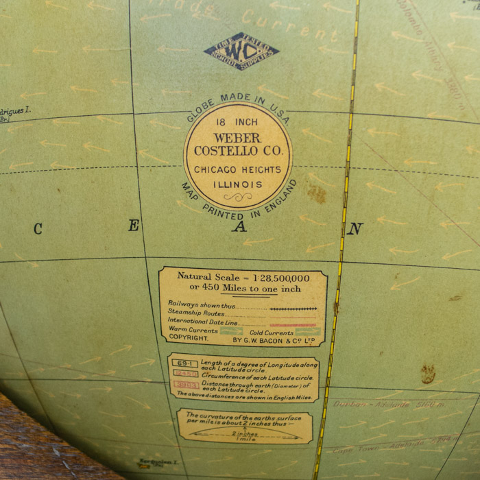
Weber Costello Diamond Cipher [above overlabel]: TIME TESTED/W.C./ SCHOOL SUPPLIES
Round Cartouche: GLOBE MADE IN U.S.A./ 18 INCH/ WEBER/COSTELLO CO./ CHICAGO HEIGHTS/ ILLINOIS/ MAP PRINTED IN ENGLAND
Reference Table [below cartouche]:
Natural Scale – 1:28,500,000 or 450 Miles to one inch
Railways shown thus
Steamship Routes
International Date Line
Warm Currents Cold Currents
COPYRIGHT. BY G.W. BACON & CO. LTD.
[There are two additional reference boxes below table — one regarding latitude and longitude, the other regarding curvature of earth’s surface.]


