Description
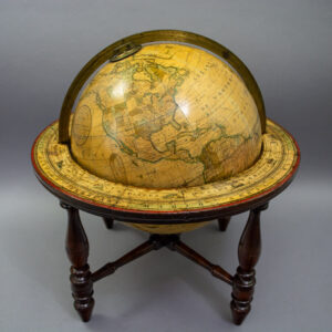
The globe has printed northern and southern hour circle polar calottes numbered I to XII twice and an incurved analemma in the Pacific Ocean with an elaborate acanthus leaf border. The equator, the ecliptic, and the prime meridian are denoted with heavy dashed lines, and the Tropics of Cancer and Capricorn are highlighted in red. Major land masses are outlined in green and blue, and mountain ranges are indicated with hatched lines. The United States west of the Mississippi River is shown as Minnesota, Iowa, Missouri, Ark., La., Texas, Oregon, Utah, N. Mexico, and California. The Baja Peninsula of Mexico is labeled Old California. Alaska is shown as “Russian Territory.” Canada is also labeled “British America,” with only the East Coast provinces named. As is typical of the era, most of the African place names provided are along the coasts, since the interior was largely unknown to Westerners; much of Southern Africa is simply labeled “Unexplored Regions.” Australia and the surrounding ocean are labeled “Austral Asia.” Antarctica is largely unmapped, except for a few short portions of coastline, with the rest labeled “Southern Ocean.” Tracks of Captain Cook’s voyages are shown, with a notation at the Sandwich Islands (present-day Hawaii) showing where he was killed in 1779. A table of “References” shows the symbols for “Largest Cities and Capitals, 2nd Class of do., 3rd Do., 4th Do.”
Franklin globes were produced throughout the second half of the 19th century in Troy, New York — with Franklin Field of Troy, New York as globe maker — by a succession companies under their own names: Merriam & Moore (1851-1852), Merriam Moore & Co. (1852-1858), Moore & Nims (1858-1868), H.B. Nims & Co. (1869-1885), Nims & Knight (1886-1889/92), and again H.B. Nims & Co. (1890/92-1896). The globes were variously available in the six, ten, twelve, sixteen, and thirty-inch diameters, with a variety of bases, generally in cast iron or wood and often reflecting the prevailing Victorian decorative arts style of the period. Models were made for both school and home parlor or library use. Collectively Franklin was one of the leading American globe makers of the 19th century in terms of quality, number and diversity of globes, and longevity of production.
Oval Cartouche: A SIX INCH AMERICAN TERRESTRIAL/ GLOBE/ Comprising/ The LATEST POLITICAL DIVISIONS,/ DISCOVERIES, & c./ MERRIAM MOORE & CO./ TROY N.Y.
Condition: Globe generally very good, recently professionally restored and revarnished, including restoration of minor abrasions and cracks, now with some light remaining toning, and wear. Horizon band in similar condition but with slightly greater remaining wear. Stand very good with usual wear and aging.