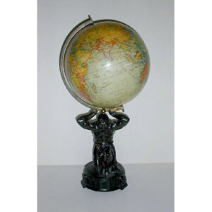
Description
The terrestrial globe has cream-colored oceans with land entities shaded in green, pink, yellow and blue, and continents outlined with a green border. North and South Dakota are shown prior to statehood in 1889 as the single region “Dacota,” and Oklahoma in its entirely as Indian Territory, as it was called before 1890. The cartography reflects Western geographic knowledge of the era, with areas unexplored by Europeans left blank. Therefore, only the coastal areas of Africa are labeled with political boundaries, while the interior is broadly labeled “Sahara or Great Desert,” “Soudan,” and “Ethiopia.” India is called “Hindoostan.” “Chinese Wall” is labeled on the northern border of China with Mongolia. Antarctica is mostly left blank, showing only the small sections of its northern coastline that had been mapped at that time; the rest is labeled “Antarctic Sea.” Short texts printed on the oceans provide historical and geographical facts about Balboa’s discovery of the Pacific Ocean, the Republic of Liberia, Napoleon’s exile on St. Helena, the establishment of the British Colony of New Zealand, and the site where Captain Cook died in the Sandwich Islands (present day Hawaii). The Atlantic Cable between Britain and the U.S. is shown as “Submarine Telegraph Cable,” as is the “Submarine Telegraph French” between the U.S. and France, completed in 1879. The tracks of the American explorer Charles Wilkes and the British explorer Captain James Cook are indicated in the oceans. The shipping route between New York and San Francisco via Aspinwall, Panama, (now Colon) is also shown. (Prior to the opening of the Panama Canal, a rail line conveyed goods across Panama between ships in the Atlantic and Pacific Oceans.) An oval “Improved Analemma” is in the Pacific Ocean.
Franklin globes were produced throughout the second half of the 19th century in Troy, New York — with Franklin Field of Troy, New York as globe maker — by a succession companies under their own names: Merriam & Moore (1851-1852), Merriam Moore & Co. (1852-1858), Moore & Nims (1858-1868), H.B. Nims & Co. (1869-1885), Nims & Knight (1886-1889/92), and again H.B. Nims & Co. (1890/92-1896). The globes were variously available in the six, ten, twelve, sixteen, and thirty-inch diameters, with a variety of bases, generally in cast iron or wood and often reflecting the prevailing Victorian decorative arts style of the period. Models were made for both school and home parlor or library use. Collectively Franklin was one of the leading American globe makers of the 19th century in terms of quality, number and diversity of globes, and longevity of production.
The offered globe more likely would have been made in the earlier phase of H.B. Nims (1869-1885) rather than the later phase (1890-96) insofar as they show Oklahoma in its entirety as Indian Territory (1890 or earlier) and Dakota as a single territory (prior to 1889 statehood). The date of manufacture can be further narrowed down to after 1879 insofar as they include the transatlantic cable between the U.S. and France.
More information about Franklin Globes and H.B. Nims can be found in our Guide to Globe Makers.
Historical and Geographical Inscriptions (as written, including punctuation):
The Pacific Ocean was discovered by Balboa in 1513. First navigated by Magellan in 1520 It extends from North to South 7500 miles and from East to west 10000 miles
The Republic of Liberia extends along the west coast of Africa from the Gallinas river 420 miles SE to the San Pedro with an average breadth inland of 10 miles comprising an area of 16,800 Square miles
In the year 1815 the late Emperor of France Napoleon Bonaparte was brought to St. Helena. In 1821 he died and was buried there In 1840 his remains were conveyed to France in the frigate Belle Poule under the command of Prince de Joinville
In the year 1840 New Zealand was annexed to the British Empire under the title of the Colony of New Zealand. The Northern I. now called New Ulster The Middle I. New Munster and the Southern I. New Leinster
Capt. Cook killed here Feb. 14th 1779
Condition: Generally very good to fine with the usual light toning, wear, and, and handling; nonetheless retaining an overall a clean glossy surface and rich bright original color. Some scattered minor abrasions, and small cracks at north pole, all professionally restored.
References:
Catalogue of School, Family and Library Globes, Dictionary, Holders, Library and Stationery Specialties. Troy, New York: H.B. Nims & Company, 1895-96, p. 3.
Dekker, Elly and van der Krogt, Peter. Globes from the Western World. London: Zwemmer, 1993. p. 135-36, 140.
Warner, Deborah Jean. “The Geography of Heaven and Earth.” Rittenhouse Journal of the American Scientific Instrument Enterprise, 1987. Vol. 2, Nos. 2 & 3, pp. 63-64, 88-89.
Glover, Bill. “History of the Atlantic Cable & Submarine Telegraphy Cable Timeline: 1845-1900.” Atlantic Cable. 5 November 2005. http://atlantic-cable.com/Cables/CableTimeLine/index1850.htm (7 October 2019).
Yonge, Ena L. A Catalogue of Early Globes, Library Series No. 6. American Geographical Society,1968. p. 53.