
Archive: Sold Maps & Views
As a service to researchers and collectors, we offer these pages where you may browse maps and views sold by the gallery since 2017. See also our maps sold between 1993-2016.
Showing 1–39 of 111 results
-

Astronomy, Celestial Chart, Bayer, Uranometria, Constellation, Delphinus, Dolphin, 17th Century (Sold)
-

Astronomy, Celestial Chart, Bayer, Uranometria, Constellation, Hare, Antique Print, 17th Century (Sold)
-
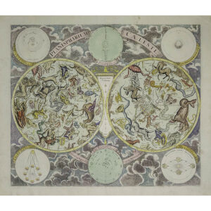
Astronomy, Celestial Chart, Double Hemisphere, Eimmart, Homann, Antique Print, Nuremberg, 18th Century
-

History, Finance, The World’s Exchanges, Root & Tinker, Antique Lithograph, 1886 (Sold)
-

Map, Astronomy, Diagram, Eclipse of the Sun, Asa Smith, Antique Watercolor, New York, 1839 (Sold)
-

Map, Boston and Vicinity, Pictorial, Ernest Dudley Chase, Vintage Print, 1938 (Sold)
-

Map, Boston, Pictorial, Birthplace of Telephone, Ernest Dudley Chase, Vintage Print, 1947 (Sold)
-
![A Pictorial Map of Boston [Fairfield & Ellis Insurance Version]](https://www.georgeglazer.com/wpmain/wp-content/uploads/2022/05/chase-boston-insurance-300x300.jpg)
Map, Boston, Pictorial, Insurance Version, Ernest Dudley Chase, Vintage Print, 1938 (Sold)
-

Map, California, Pictorial, California, Jo Mora, Vintage Print, 1945 (Sold)
-

Map, Canada, Ontario, Kingston, Pictorial, Vintage Print, 1948 (Sold)
-

Map, Canada, Pictorial, Canadian Pacific Railway, Vintage Print, c. 1945 (Sold)
-

Map, Cartographic Curiosity, Folding Fan, Sudlow, London, Antique, c. 1793 (Sold)
-

Map, Celestial, Northern Hemisphere, Antique Print, Desnos, Paris, 1770 (Sold)
-

Map, Central America, Costa Rica, Pictorial, Vintage Print (Sold)
-

Map, China, Peking, John Kirk Sewall, Peiyang Press: Pictorial Map, c. 1938-45 (Sold)
-

Map, Connecticut & New York, Pictorial, Greenwich, Rye, Garden Club,1927 (Sold)
-

Map, Connecticut, Pictorial, Connecticut College, New London, 1934 (Sold)
-

Map, Europe, Pictorial, Ernest Dudley Chase, Vintage Print, 1938 (Sold)
-

Map, Florida, Pocket Map, Colton, New York, 1884 (Sold)
-

Map, Florida, Sarasota, Pictorial, Thornton Utz, Vintage Print, 1960s (Sold)
-

Map, France, Regional, Cartographic Curiosity, Set of Map Cards, 19th Century (Sold)
-
![Alexandri Magni Macedonis Expeditio [Alexander the Great's Macedonian Empire]](https://www.georgeglazer.com/wpmain/wp-content/uploads/2022/01/jansson-macedonia-300x300.jpg)
Map, Greece, Macedonian Empire of Alexander the Great, Jansson, Antique Print, Amsterdam, c. 1652-1662 (Sold)
-
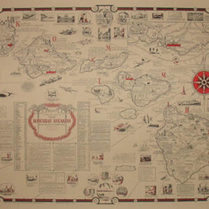
Map, Hawaii, Pictorial, Ernest Dudley Chase, Vintage Print, 1960 (Sold)
-

Map, Hawaii, Pictorial, Parker Edwards for Dole, Vintage Print, 1937 (Sold)
-
![Ortelius Map of Islandia [Iceland]](https://www.georgeglazer.com/wpmain/wp-content/uploads/2020/03/ortelius-islandia-300x300.jpg)
Map, Iceland, Islandia, Abraham Ortelius, Sea Monsters, 1608 (Sold)
-

Map, Illinois, Midwest, Pictorial, Abraham Lincoln, Vintage Print, 1934 (Sold)
-
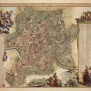
Map, Italy, Rome, Novissima et Accuratissima Romae, G.B. Falda, Antique Print, 1690s (Sold)
-

Map, Long Island, Nassau County, Set of 6 Antique Prints, Hyde, 1923 (Sold)
-

Map, Massachusetts, Cape Ann and the North Shore, Pictorial, Vintage Print, 1934 (Sold)
-

Map, Massachusetts, Nantucket Island, Pictorial, Fred H. Gardner, Vintage Print, 1933 (Sold)
-

Map, Massachusetts, Nantucket, Pictorial, Austin Strong, Vintage Print, 1921 (Sold)
-

Map, Massachusetts, Nantucket, Pictorial, Judith Learmont, Original watercolor, 1946 (Sold)
-

Map, Massachusetts, Wellesley College, Pictorial, Rosalind Howe Sturges, 1943 (Sold)
-

Map, Military, World War II, Pictorial, Set of 6 Ceramic Tiles (Sold)
-

Map, Montana, Pictorial, Irvin Shope, Vintage Print, 1937 (Sold)
-

Map, New Jersey, Pictorial, Princeton University, Vintage Print, 1945 (Sold)
-

Map, New York City, Beekman Hill, John Holmes, Antique Print, 1870 (Sold)
-

Map, New York City, Brooklyn, F.W. Beers, Antique Print, 1867 (Sold)
$400 -

Map, New York City, Brooklyn, Pocket Map, Matthew Dripps, Antique Print, 1869 (Sold)