A New & Accurate Chart of the World
Emanuel Bowen, London: 1744
Copperplate engraving with later hand color
Black frame with Elaborate gilt inner border
15 x 19 inches
22 x 25 inches, framed
Sold, please inquire as to the availability of similar items.

A new & Accurate Chart of the World
Emanuel Bowen, 1744
Emanuel Bowen, 1744
This item is sold. It has been placed here in our online archives as a service for researchers and collectors.
- Please inquire as to the availability of similar items currently in stock, or use the navigation bar above to browse our site for currently available items.
- Find guidelines for the use of images from georgeglazer.com.
- To see more archived items, view our directory.
- Find information about selling your art and antiques.

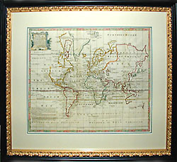
An 18th Century map of the world on Mercator's Projection, showing "variations of the compass" by curved and dotted lines. Geographical entities outlined in various colors, border colored alternating pink and green.
The problem of "variations of the compass" vexed sailors from the Age of Discovery, making it difficult to measure longitude at sea and stay on course. As they steered their ships along a latitude they noted that the compass needle varied unexpectedly, the position of magnetic north shifting with the position of the ship. This was a critical problem that some of the great scientific minds of the 17th and 18th Centuries worked at solving. By 1638, it was known that there are alterations in the magnetic field of the earth which vary over time and location. In 1698, eminent scientist Edmund Halley arranged a voyage through the Atlantic where he measured the magnetic variation from true north and then used these data to plot lines of equal variation for the year 1700. Halley's research showed it would be theoretically possible to use such a map if a great enough spread of reference values were monitored year by year. This was not possible until the 20th century, with the advent of satellite technology.
Reference:
"Three Theories of Longitude Solution," http://rubens.anu.edu.au/student.projects97/naval/three.htm