G.W. & C.B. Colton
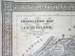
Travellers Map of Long Island
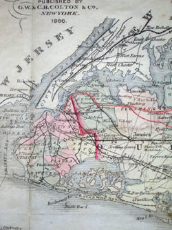
G.W. & C.B. Colton, New York: 1866
Folds as issued into black blind-stamped cloth covers
8.75 x 22.25 inches, printed border
10.5 x 24 inches, overall
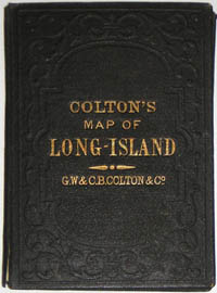
4.75 x 3.5 inches, cover
Sold, please inquire as to the availability of similar items.

Colton Travellers Map of Long Island
New York: 1866
New York: 1866
This item is sold. It has been placed here in our online archives as a service for researchers and collectors.
- Please inquire as to the availability of similar items currently in stock, or use the navigation bar above to browse our site for currently available items.
- Find guidelines for the use of images from georgeglazer.com.
- To see more archived items, view our directory.
- Find information about selling your art and antiques.
 |
 |
 |
 |
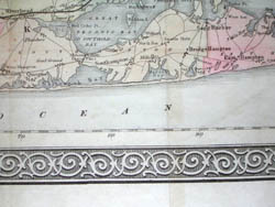 |
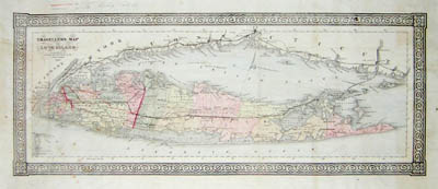
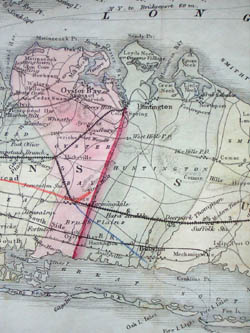
Pocket map of Long Island showing counties in shades of pink, green, and yellow with railroads and major roads depicted. Decorated with a simple arabesque border typical of Colton maps. Manuscript notations and lines in orange and blue colored pencil, apparently 19th century, indicate proposed (or possibly actual) extensions of rail lines, the key to which is in the upper margin. Orange pencil lines show rail line extensions mainly within Queens, while a blue pencil line shows a rail line extension from Bethpage to Babylon.
Long Island was among the first areas in the New World reached by European settlers. The town of Southampton on the eastern tip was settled in 1640. The island and its coast were mapped in the 18th century by the British up to the time of the Revolutionary War. By the end of the 19th century, the Long Island Railroad (LIRR) was actively promoting travel and settlement of the island, and issued numerous maps for this purpose. Private publishers such as the Colton family also responded to this interest.
Between 1831 and 1890, the Colton firm dominated American map publishing and their atlases were the finest produced in the U.S. during the 19th century. The company was founded by Joseph H. Colton, who had no formal training in geography or cartography; his principal role was to manage the production and distribution of the maps. He began by publishing maps drawn by David H. Burr in the 1830s. The firm was renamed G.W. & C.B. Colton in the 1860s when Colton was succeeded by his sons -- George Woolworth Colton (1827-1901) and Charles B. Colton (c. 1831-1916). It is believed that George Colton compiled the company’s 1855 Atlas of the World and served thereafter as the firm’s principal map compiler, cartographer and engraver. The company continued to publish maps and atlases until 1892. Whether they were bought out or simply ceased production at that point is not known. According to map historian Walter W. Ristow: “At that date, wax engraving had been adopted as a reproduction medium by most of the large American cartographic publishers. Having built their business on engraving and lithography, the Coltons were apparently unwilling to reorganize it.”
References:
Cohen, Paul E. and Augustyn, Robert T. Manhattan in Maps: 1527-1995. New York: Rizzoli, 1997. p. 120.
Ristow, Walter W. American Maps & Mapmakers: Commercial Cartography in the 19th Century. Detroit, MI: Wayne State University Press, 1985. pp. 325, 327.