D. Francisco Coello (1822-1898) (editor)
D. Pascual Madoz (surveyor)
Leclercq, Desbuissons (after)
Bacot (author)
Posesiones de Africa [African Possessions]
issued with Diccionario Geografico Estadistico Historico – Atlas de España y sus Posesiones de Ultramar [Historical Statistical Geographic Dictionary -- Atlas of Spain and Its Overseas Possessions]
D. Francisco Coello, Madrid: 1850
Hand colored lithograph, backed on linen, folding, as issued
Blind stamp lower right of Madoz y Coello
29.5 x 41 inches, printed border
33 x 43.75 inches, overall
Sold, please inquire as to the availability of similar items.

Spanish Colonial Map of Africa
D. Francisco Coello, Mapmaker
D. Francisco Coello, Mapmaker
This item is sold. It has been placed here in our online archives as a service for researchers and collectors.
- Please inquire as to the availability of similar items currently in stock, or use the navigation bar above to browse our site for currently available items.
- Find guidelines for the use of images from georgeglazer.com.
- To see more archived items, view our directory.
- Find information about selling your art and antiques.
 |
 |
 |
 |
 |
 |
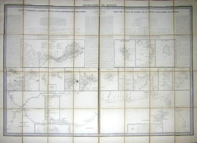
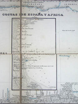
Large folding map of mid 19th century Spanish colonial possessions in Africa, having two sections divided into regions of the west and northwest coasts labeled as follows:
Islas y Presidios Situados en la Costa Septentrional de Africa [Islands and Garrisons Situated on the Northern Coast of Africa] and Islas del Golfo de Guinea en la Costa Occidental de Africa [Islands of the Gulf of Guinea on the Western Coast of Africa].
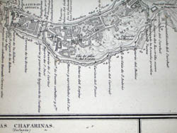
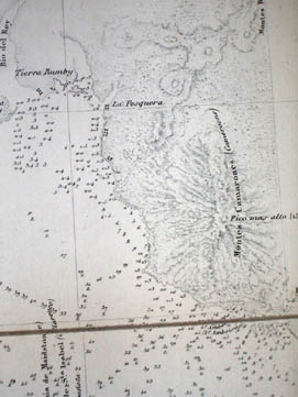
The map is executed in great detail, with subtleties in topography clearly visible, as well as having a number of inset maps. Sea depths are marked, as well as the names of buildings in inset maps of towns.
Coello and Madoz’s Diccionario Geografico Estadistico Historico was a collection of maps and data that formed an overseas atlas of Spain and its territorial possessions, the first such systematic and scientific work to be produced in Spain. Prior to the production of these maps, Spanish officials had to consult maps of Spain made by the French military.
D. Francisco Coello (1822-1898) is considered the foremost Spanish mapmaker and cartographer of the 19th century and one of the pillars of the development of cartography in Spain. In countries like France, the systematic mapping of the nation according to scientific precepts had been undertaken in the 18th century, but Spain lagged behind. The information Coello compiled became the documentary basis for later projects undertaken by the Geographic and Statistical Institute. Coello was a career soldier, apprenticed to the military as a child of 11, and by age 14 was enrolled in the academy training military engineers. There he found his true vocation of geography. In 1841 he began collaborating with D. Pascual Madoz in the production of an atlas of Spain and its overseas possessions. By 1846 he had successfully applied to the military for permission to dedicate himself to cartographic projects, and traveled to Paris on several occasions to obtain data as needed. Meanwhile, he held important positions in the General Statistics Commission of Spain and published numerous maps and plans of nations and cities until he retired from the army in 1866. Coello’s work was esteemed by colleagues within and outside of Spain, and he was made a member of the Academy of History in 1874. The following year he helped establish the Geographic Society of Madrid and served as president in 1876.
Reference:
Gómez, Lourdes Roldán. “Francisco Coello y La Cartografía Española del S. XIX.” Universidad Autónoma de Madrid. http://www.ffil.uam.es/catalogo/madrid/lourdes.htm (5 August 2004).